
Cedar Sink
collapse sinkhole·United States·limestone
Cedar Sink is a large, vertical-walled sinkhole located within Mammoth Cave National Park in Edmonson County, Kentucky. It is a significant example of karst topography, formed by the dissolution of soluble rocks and subsequent collapse of the surface, revealing an underground drainage system. The sinkhole's unique geomorphology and ecological features make it a notable natural landmark within the park.
Key Facts
- ›Measures 300 feet (91.4 M) from the plateau top to the bottom.
- ›Has a bottom area of approximately 7 acres (2.8 ha).
- ›Characterized by fertile soil compared to surrounding ridgetops.
- ›Exposes the Ste. Genevieve Limestone at its bottom.
- ›Serves as a karst window, with an ephemeral stream visible seasonally.
- ›Part of a karst topography system influenced by the dissolution of limestone.
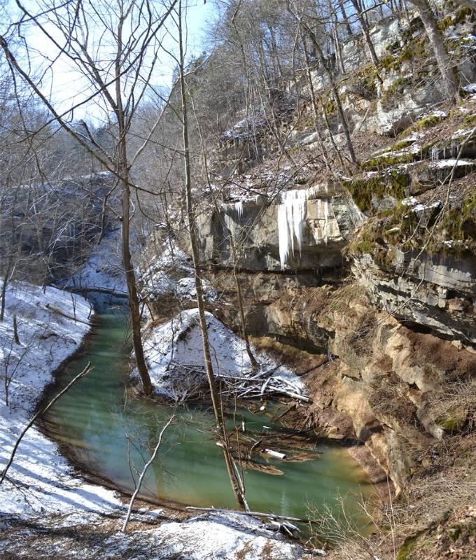
Karst Window, Ephemeral Stream, Fertile Soil
Chologaster Agassizii, Question Mark Butterfly, Tussock Moth, Red-Spotted Purple, Red Admiral
About Cedar Sink
Cedar Sink is a prominent vertical-walled depression, or sinkhole, located within Mammoth Cave National Park in Edmonson County, Kentucky. This natural feature is a significant example of karst topography, a landscape shaped by the dissolution of soluble rocks like limestone, which creates underground drainage systems, caves, and sinkholes.
Geomorphology and Formation
The geological foundation of Cedar Sink dates back to the Mississippian subperiod, approximately 358.9 to 323.2 million years ago. The sinkhole's formation is a result of subsurface collapse. Initially, the Big Clifty Sandstone caprock was breached, exposing the underlying Girkin Formation limestone. This process, combined with the erosion and undercutting action of an ancestral master drainage line, weakened the cave ceiling. Eventually, a significant collapse occurred, creating the large depression and exposing the Ste. Genevieve Limestone at its bottom. The presence of an ephemeral stream, visible seasonally, and the exposure of the subsurface drainage system classify Cedar Sink as a karst window.
Dimensions and Characteristics
Cedar Sink is substantial in size, measuring approximately 300 feet (91.4 meters) from the surrounding sandstone plateau down to its bottom. The sinkhole encompasses a bottom area of about 7 acres (2.8 hectares). Notably, the soil at the bottom of Cedar Sink is more fertile compared to the ridgetops, supporting a distinct ecological community.
Ecology
The fertile and water-retentive soils within Cedar Sink contribute to a rich vegetative environment. Scientists have noted changes in the ecosystem due to historical farming and grazing practices prior to the park's establishment. The area supports a variety of trees, shrubs, and ground vegetation, including species such as maples, hickories, tulip trees, oaks, and elms. The sinkhole is also a habitat for various organisms, including the endemic spring cavefish, Chologaster agassizii, as well as several species of butterflies and moths.
Recreation and Access
Cedar Sink is accessible to visitors via a clearly delineated trail that extends about three-quarters of a mile along the Smith Valley floor. The 1.6-mile round trip trail includes numerous stairs and vista platforms, offering glimpses into the former underground river system and views of ephemeral springs. The trail circles the southern edge of the sink and leads to an overlook. Geocaching is a popular recreational activity within the Cedar Sink area.
Source: Wikipedia ↗
Frequently Asked Questions
What is Cedar Sink?
Cedar Sink is a large, vertical-walled depression or sinkhole located in Edmonson County, Kentucky, within Mammoth Cave National Park. It is a prime example of karst topography, where the dissolution of soluble rocks leads to the formation of underground drainage systems and surface collapses.
How was Cedar Sink formed?
Cedar Sink was formed by the collapse of surface soil and rock. This occurred after an underground master drainage line, weakened by continuous flow and undercutting, eventually led to the collapse of the ceiling, exposing the subsurface stream and creating the sinkhole.
What are the dimensions of Cedar Sink?
The sinkhole measures approximately 300 feet (91.4 meters) from the top sandstone plateau to its bottom. The bottom area of Cedar Sink covers about 7 acres (2.8 hectares).
What kind of geology is found at Cedar Sink?
The rocks in the Cedar Sink area are from the Mississippian subperiod. The sinkhole features a caprock of Big Clifty Sandstone, exposing the Girkin Formation limestone, and the Ste. Genevieve Limestone at its deepest point.
Is there water in Cedar Sink?
Water from an ephemeral stream can be seen in Cedar Sink seasonally, depending on precipitation events. The exposure of this subsurface stream makes Cedar Sink a karst window.
What is the ecology like at Cedar Sink?
Cedar Sink boasts fertile soils with high water content, supporting abundant vegetation. It is home to various tree species, shrubby plants, ground vegetation, and wildlife, including the spring cavefish Chologaster agassizii.
What activities can be done at Cedar Sink?
Visitors can explore Cedar Sink via a 1.6-mile round trip trail that follows the Smith Valley floor and circles the southern edge of the sink, leading to an overlook platform. Geocaching is also a popular activity in the area.
Related Sinkholes

Big Basin Prairie Preserve
The Big Basin Prairie Preserve in Kansas encompasses a significant sinkhole system, most notably the mile-wide Big Basin and the water-filled St. Jacob's Well. These geological features, formed by sinkhole activity, are historically notable as resting places for the Northern Cheyenne and landmarks for cattle drives. The preserve is a designated National Natural Landmark, managed to protect its unique landscape and wildlife.

Devil's Millhopper Geological State Park
Devil's Millhopper Geological State Park features a massive sinkhole in Florida, notable for its exposed limestone layers and the unique ecological environments it supports. The sinkhole's formation through limestone dissolution has created a dramatic geological record, making it a significant site for scientific study and public appreciation of karst topography.

Devil's Sinkhole State Natural Area
Devil's Sinkhole State Natural Area is a significant natural reserve in Texas, primarily known for its massive colony of Mexican free-tailed bats. The sinkhole itself is a large vertical cavern, with a notable opening and a substantial depth, making it a crucial habitat for these bats and a site of geological interest. It was officially recognized as a National Natural Landmark in 1968 and opened to the public in 1992.