
Gorges du Tarn
River Canyon·France·Mesozoic·Tarn
The Gorges du Tarn is a dramatic canyon carved by the Tarn River in southern France, situated between the Causse Méjean and Causse de Sauveterre plateaux. This impressive geological formation, primarily in the Lozère and Aveyron departments, stretches approximately 53 kilometers and plunges to depths of 400 to 600 meters, showcasing Mesozoic limestone cliffs and evidence of Quaternary volcanic activity. It is a significant destination for outdoor recreation and historical exploration, dotted with medieval castles.
Key Facts
- ›Approximately 53 kilometers long, extending from Quézac to Le Rozier.
- ›Maximum depth ranges from 400 to 600 meters.
- ›Primarily composed of Mesozoic limestone, with sub-vertical cliffs.
- ›Geology influenced by faults, leading to significant water sources.
- ›Evidence of Quaternary volcanic activity, including basaltic rocks.
- ›Features numerous medieval castles along its course.

Gòrjas de Tarn
River Erosion
Mesozoic Limestone Plateaux, Sub-Vertical Cliffs, Hauterive Fault, Burle Source, Coussac Source, Quaternary Volcanic Activity, Basaltic Rocks, Medieval Castles
GòRjas De Tarn
About Gorges du Tarn
The Gorges du Tarn, known in Occitan as Gòrjas de Tarn, is a significant natural landmark in southern France, sculpted by the Tarn River. This impressive canyon lies between the Causse Méjean and Causse de Sauveterre, two vast limestone plateaux, and is primarily situated within the Lozère département, with a portion extending into the Aveyron département.
Geography and Geology
The canyon's landscape is defined by its Mesozoic limestone formations, presenting dramatic sub-vertical cliffs. The geological history of the Gorges du Tarn is complex, influenced by fault lines such as the Hauterive Fault, which contributes to substantial water sources in the area, including the notable Burle and Coussac springs. Further shaping occurred during the Quaternary period with volcanic activity, leaving traces like anticlinal volcanic dips and basaltic rocks near Eglazines on the Causse de Sauveterre.
The climate of the Gorges du Tarn is Mediterranean, characterized by mild winters and very warm summers, creating a distinct environmental setting.
Tourism and Architecture
Tourism is a vital economic driver for the region, offering a variety of outdoor activities. Visitors can engage in hiking, kayaking, and rock climbing, as well as caving in the surrounding Causses. The area also boasts charming, typical villages such as Cirque de Saint-Chély-du-Tarn, making it a popular destination for both adventure and cultural exploration.
Historically, the Gorges du Tarn was a strategic location, evidenced by the numerous castles constructed along its steep walls. Many of these fortifications, including those at Castelbouc, Lacaze, Hauterives, La Malène, and Saint-Rome-de-Dolan, date back to the Middle Ages, adding a rich historical dimension to the canyon's natural beauty.
Source: Wikipedia ↗
Frequently Asked Questions
How was the Gorges du Tarn formed?
The Gorges du Tarn was formed by the erosive power of the Tarn River cutting through the limestone plateaux of Causse Méjean and Causse de Sauveterre. Geological processes, including faulting and volcanic activity in the Quaternary period, also shaped its complex landscape.
What are the main geographical features of the Gorges du Tarn?
The canyon is characterized by sub-vertical cliffs of Mesozoic limestone. It is also notable for significant water sources, such as the Burle and Coussac springs, and includes areas with basaltic rocks from past volcanic activity.
What activities can visitors enjoy in the Gorges du Tarn?
The region offers a wide range of activities for tourists, including hiking, kayaking, caving in the surrounding Causses, rock climbing, and exploring picturesque villages. Outdoor sports and leisure activities are also popular.
Are there historical structures in the Gorges du Tarn?
Yes, the Gorges du Tarn is home to many historical castles, most of which date back to the Middle Ages. Notable examples include the castles of Castelbouc, Lacaze, Hauterives, La Malène, and Saint-Rome-de-Dolan.
What is the climate like in the Gorges du Tarn?
The climate in the Gorges du Tarn is Mediterranean. This means it experiences relatively mild winters and very warm summers.
Related Canyons

Verdon Gorge
The Verdon Gorge, also known as Gorges du Verdon, is a spectacular river canyon in southeastern France, carved by the Verdon River over millions of years through limestone massifs. Stretching approximately 25 km and reaching depths of up to 700 meters, its turquoise waters and towering limestone walls make it a significant natural wonder and a popular destination for tourism and outdoor sports.

Daluis Gorge
The Gorges de Daluis is a 6 km long canyon carved by the Var River in the Alpes-Maritimes department of southeastern France. Its distinctive red walls are composed of sandstone dating back 260 million years, colored by iron oxide. The gorge is a significant geological feature and a popular tourist destination, offering scenic views, recreational activities, and historical insights.
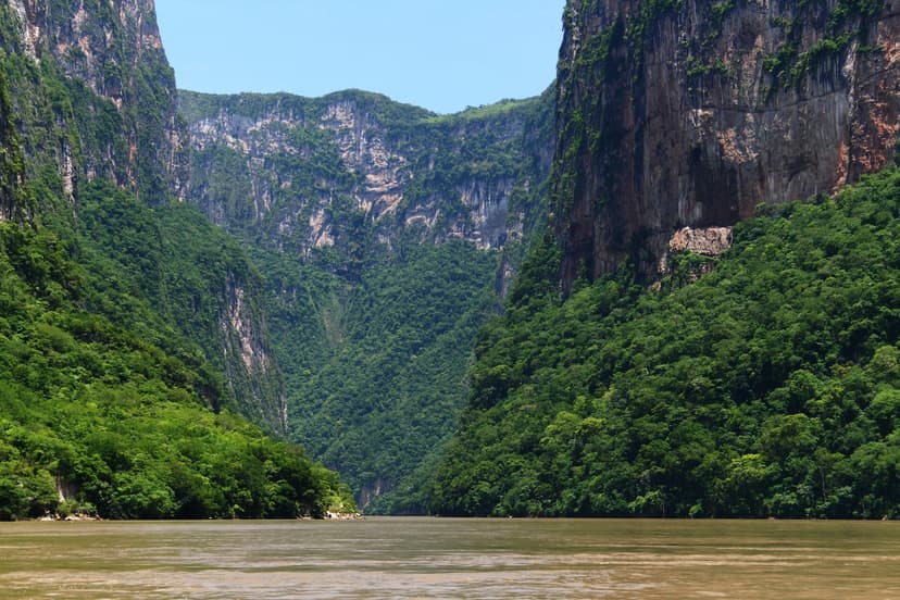
Sumidero Canyon
Sumidero Canyon is a deep natural canyon in Chiapas, southern Mexico, carved over millions of years by the Grijalva River. Its formation began concurrently with the Grand Canyon, shaped by tectonic crustal cracks and river erosion. The canyon is a significant natural landmark and a major tourist attraction, renowned for its towering vertical walls and unique geological formations, while also facing considerable environmental challenges.