
Sumidero Canyon
River Canyon·Mexico·Mesozoic·Grijalva River
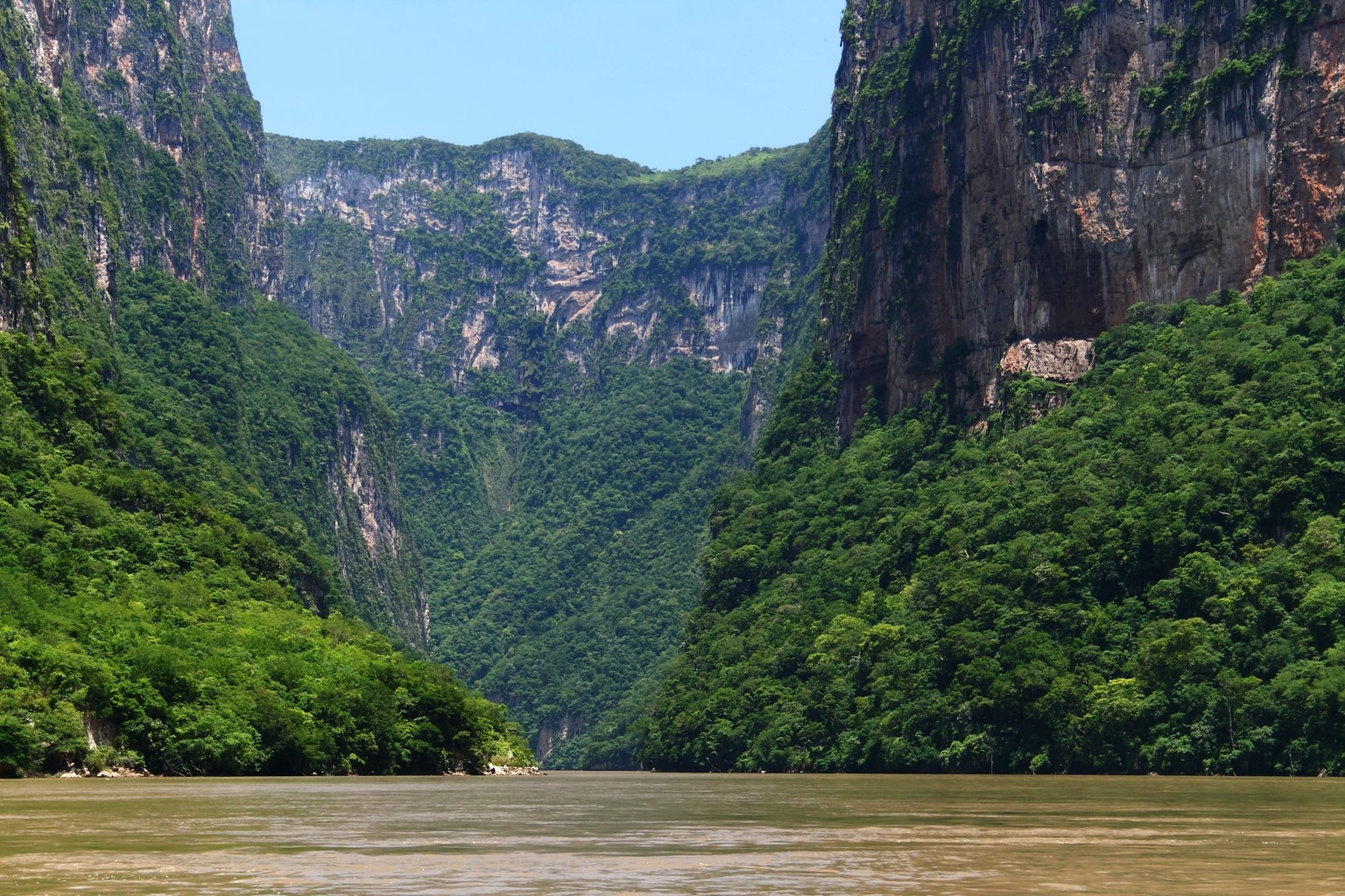
Sumidero Canyon is a deep natural canyon in Chiapas, southern Mexico, carved over millions of years by the Grijalva River. Its formation began concurrently with the Grand Canyon, shaped by tectonic crustal cracks and river erosion. The canyon is a significant natural landmark and a major tourist attraction, renowned for its towering vertical walls and unique geological formations, while also facing considerable environmental challenges.
Key Facts
- ›Vertical canyon walls reach up to 1,000 meters (3,300 ft) in height.
- ›The canyon is 13 kilometers (8 MI) long, with the Grijalva River making turns up to 90 degrees within its passage.
- ›It is located within the Sumidero Canyon National Park, a protected area of 21,789 hectares.
- ›The canyon's formation began approximately 35 million years ago.
- ›The primary rock type found in the canyon walls is limestone from the Upper Mesozoic era.
- ›Notable features include the Cueva de Colores, Cueva de Silencio, and the Árbol de Navidad waterfall formation.
River Erosion, Tectonic Activity
Cueva De Colores, Cueva De Silencio, Caballito De Mar Stalactite, áRbol De Navidad Waterfall, Vertical Limestone Walls, Meseta De Las Animas, Meseta De Ixtapa
American Crocodile, Central American River Turtle, Spider Monkey, Jaguarundi, Ocelot, Great Curassow, River Crocodile, YucatáN Banded Gecko
Deciduous Rainforest, Pine-Oak Forest, Grassland, Perennial Rainforest, Pachycaulous Vegetation
About Sumidero Canyon
Sumidero Canyon, known in Spanish as Cañón del Sumidero, is a remarkable natural gorge situated in the state of Chiapas, southern Mexico. Its creation commenced approximately 35 million years ago, a process driven by tectonic activity that fractured the Earth's crust, followed by the persistent erosive force of the Grijalva River, which continues to flow through its depths. The canyon is distinguished by its sheer, vertical walls that ascend to heights of up to 1,000 meters (3,300 ft), with the river carving a sinuous path that turns as much as 90 degrees along its 13-kilometer (8-mile) course.
Geology and Formation
The geological history of Sumidero Canyon is intrinsically linked to the Grijalva River, which originates in Guatemala and traverses Chiapas. The canyon's formation, initiated by crustal rifting, is contemporaneous with that of the Grand Canyon in Arizona. The canyon's walls reveal layers of limestone from the Upper Mesozoic era, containing fossils of marine life, indicative of ancient oceanic environments. The varied terrain also features underground water movements that have sculpted caves and karst formations.
Notable Features and Ecosystems
The canyon is a biodiversity hotspot, enclosed within the Sumidero Canyon National Park, a federally protected area covering 21,789 hectares. The park's vegetation ranges from dense deciduous rainforests to pine-oak forests and grasslands. Notable geological features within the canyon include various caves, such as the vibrantly colored Cueva de Colores and the acoustically unique Cueva de Silencio. Seasonal waterfalls, like the moss-covered Árbol de Navidad, add to the canyon's scenic beauty. The area is also home to endangered species, including the American crocodile and the Central American river turtle.
Tourism and Conservation Challenges
Sumidero Canyon is a significant tourist destination, drawing visitors primarily from Mexico who experience its grandeur via boat tours departing from Chiapa de Corzo. However, the canyon and its surrounding park face substantial environmental pressures. Pollution from upstream urban and industrial activities contaminates the Grijalva River, leading to the accumulation of large amounts of solid waste within the canyon, exacerbated by the Chicoasén Dam. Human encroachment from the expanding city of Tuxtla Gutiérrez also poses a threat, leading to habitat loss and deforestation. Despite these challenges, the rugged terrain in many sections helps preserve parts of the ecosystem.
Source: Wikipedia ↗
Frequently Asked Questions
How was Sumidero Canyon formed?
Sumidero Canyon was formed by cracks in the Earth's crust combined with erosion by the Grijalva River. This geological process began around 35 million years ago, making it contemporary with the formation of the Grand Canyon.
What are the dimensions of Sumidero Canyon?
The canyon is approximately 13 kilometers (8 miles) long. Its vertical walls can reach up to 1,000 meters (3,300 ft) high, and its width varies from 1 to 2 kilometers (3,300 to 6,600 ft).
What kind of plants and animals can be found in Sumidero Canyon?
The vegetation in the park is predominantly low- to medium-height deciduous rainforest, with areas of pine-oak forest and grassland. Wildlife includes numerous bird species, reptiles like the American crocodile, and mammals such as spider monkeys and jaguars.
What are the main tourist activities at Sumidero Canyon?
The primary tourist activity is taking boat tours on the Grijalva River, which depart from Chiapa de Corzo. Visitors can observe the canyon's impressive walls, unique rock formations, and wildlife from the river.
What conservation issues does Sumidero Canyon face?
The most significant conservation issue is the contamination of the Grijalva River due to pollution from upstream urban areas and logging industries. Human encroachment and illegal settlements within the national park also pose threats to the ecosystem.
Related Canyons

Copper Canyon
Copper Canyon, also known as Barrancas del Cobre, is a vast network of six interconnected canyons located in the Sierra Madre Occidental of northwestern Mexico. These canyons were carved by six rivers that originate in the Sierra Tarahumara and eventually merge into the Rio Fuerte, emptying into the Gulf of California. The name "Copper Canyon" derives from the distinctive copper-green hue of its canyon walls, and the region holds significant cultural importance for the indigenous Tarahumara (Rarámuri) people.

Barranca de Oblatos
Barranca de Oblatos, also known as Barranca de Huentitán, is a significant canyon located in Jalisco, Mexico, carved by the Río Grande de Santiago. Its striking geological features bear a resemblance to the Grand Canyon and Barranca del Cobre, and it serves as a vital biogeographic corridor within the Guadalajara Metropolitan Area. The canyon is recognized as a protected ecological zone, hosting diverse flora and fauna, and has been a site of historical conflict and development.

Vikos Gorge
The Vikos Gorge is a dramatic gorge located in the Pindus Mountains of northwestern Greece, renowned for being the deepest canyon relative to its width in the world. Carved over millions of years by the Vikos Stream and the Voidomatis River, it showcases diverse geological strata and ecosystems. Historically, the area was utilized for pastoralism and is significant for its unique flora, with local healers known as "Vikos doctors" using medicinal herbs found within the gorge.