
Big South Fork of the Cumberland River
River Canyon·North America·Carboniferous·Cumberland River
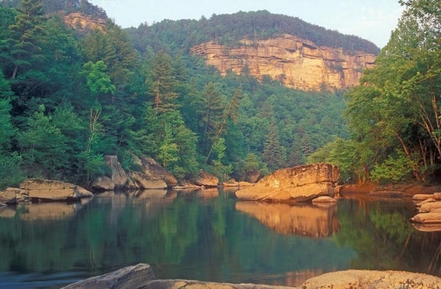
The Big South Fork of the Cumberland River is a significant river system in Tennessee and Kentucky, carved into the Cumberland Plateau. This 76-mile waterway is characterized by rugged terrain with deep gorges, natural arches, and rock shelters, and is the central feature of the Big South Fork National River and Recreation Area. Its formation by river erosion has created a diverse ecosystem and a popular destination for outdoor recreation.
Key Facts
- ›The river flows for approximately 76 miles (122 km) through Tennessee and Kentucky.
- ›The upstream terrain is rugged, with reliefs up to 1,900 feet (580 M), featuring natural arches, mesas, and rock shelters.
- ›The Big South Fork is a major tributary of the Cumberland River, draining a basin of Carboniferous rock.
- ›Water quality can be affected by historical mining activities, but both states designate the river as Outstanding National Resource Waters.
- ›The Big South Fork National River and Recreation Area was established to conserve its cultural, historic, geologic, and scenic values.
- ›Whitewater rafting and kayaking are popular activities, with runs ranging from Class I to IV in difficulty.
River Erosion
Natural Arches, Mesas, Chimneys, Cracks, Rock Shelters, Blue Heron Outdoor Museum
Channel Catfish, Walleye, Muskellunge, White Bass, Rock Bass, Longear Sunfish, Ruffed Grouse, Turkey, Eastern Gray Squirrel, Red-Eyed Vireo, Hooded Warbler, American Redstart, Smoky Shrew, Eastern Mole, Eastern Woodrat, White-Footed Mouse, Barred Owl, Red-Shouldered Hawk, Black Bear
Mixed Oak Forests, Mixed Mesophytic Vegetation, Sugar Maple, Beech, Yellow Birch, Canadian Hemlock, Rhododendron Maximum, Pine Species
About Big South Fork of the Cumberland River
The Big South Fork of the Cumberland River is a significant river system located in the U.S. states of Tennessee and Kentucky. It serves as a major tributary to the Cumberland River and is the central geographical feature of the Big South Fork National River and Recreation Area. The river is approximately 76 miles (122 km) in length and winds through the rugged terrain of the Cumberland Plateau, characterized by dramatic gorges, natural arches, mesas, and rock shelters. Its formation is primarily attributed to long-term river erosion.
Physical Geography and Hydrology
The river originates at the confluence of the New River and the Clear Fork in Scott County, Tennessee, and flows generally northwest, northeast, and north before emptying into Lake Cumberland in McCreary County, Kentucky. The upstream sections are notably rugged, with reliefs reaching as much as 1,900 feet (580 m), featuring narrow gorges and valleys strewn with large boulders. As the river progresses northward, the terrain becomes less dramatic, with reliefs between 200 and 300 feet (61-91 m). The drainage basin is underlain by Carboniferous rock. Hydrologically, the Big South Fork experiences significant seasonal flow variations, with peak streamflow typically occurring from January to March and lowest flows in September and October. Water quality, while generally good, can be impacted by historical mining activities, though cleanup efforts are ongoing and both Tennessee and Kentucky have designated their portions as Outstanding National Resource Waters.
History and Recreation
Archaeological evidence suggests the area was utilized by Paleo-Indians and continued to be frequented through early colonial times, with an estimated 10,000 archaeological sites identified. The first permanent European settlement is believed to have been established in 1769. The land was largely bypassed by settlers until the late 19th century, with the notable attempt to found the colony of Rugby, Tennessee. The mining community of Blue Heron, Kentucky, operated along the river from 1937 to 1962 and has since been restored as an outdoor museum. The Big South Fork National River and Recreation Area was established by Congress in 1974 to preserve the river's natural beauty and recreational potential. The area is a popular destination for outdoor enthusiasts, offering whitewater rafting and kayaking on runs that range from Class I to IV in difficulty, particularly during the spring season. The park also protects diverse habitats supporting a wide array of plant and animal species, including reintroduced black bears.
Source: Wikipedia ↗
Frequently Asked Questions
What geological features are found in the Big South Fork of the Cumberland River?
The Big South Fork's terrain is marked by dramatic reliefs, particularly upstream, featuring natural arches, mesas, chimneys, cracks, and rock shelters. These formations are a result of erosion within the Cumberland Plateau.
What are the primary activities available at the Big South Fork?
The Big South Fork National River and Recreation Area offers a variety of outdoor activities. Whitewater rafting and kayaking are popular, especially in the spring, with runs varying in difficulty. The area also provides opportunities for hiking and exploring its natural and cultural sites.
How was the Big South Fork of the Cumberland River formed?
The river was formed primarily by river erosion over a long geological period, carving out the rugged landscape of the Cumberland Plateau. Its drainage basin is composed of Carboniferous rock.
When is the best time to visit the Big South Fork for whitewater activities?
Whitewater rafting and kayaking on the Big South Fork are most prevalent during the spring season. The river's flow during this time is suitable for runs ranging from Class I to IV, depending on the specific section.
What is the significance of the Big South Fork National River and Recreation Area?
This area was established to conserve and interpret unique cultural, historic, geologic, fish and wildlife, archeological, scenic, and recreational values. It aims to preserve the Big South Fork as a natural, free-flowing stream for present and future generations.
Related Canyons

Big Bend National Park
Big Bend National Park is a vast protected area in West Texas, notable for its extensive Chihuahuan Desert topography and ecology. Formed by the erosive power of the Rio Grande and significant geological uplift, the park preserves a rich tapestry of life, including over 1,200 plant species and hundreds of animal species, as well as ancient fossils and diverse rock formations. Its remote location and dramatic landscapes, including the Chisos Mountains and deep river canyons, make it a significant destination for naturalists and adventurers.

Black Canyon of the Gunnison
The Black Canyon of the Gunnison is a dramatic gorge in western Colorado, carved by the Gunnison River. Its name derives from the fact that its sheer walls receive very little sunlight, often appearing black. The canyon is renowned for its extreme depth, steepness, and narrowness, combining these features into a formidable and awe-inspiring landscape.

Canyonlands National Park
Canyonlands National Park is a national park in southeastern Utah, celebrated for its dramatic landscape of canyons, mesas, and buttes carved by the Colorado and Green Rivers. Established in 1964, it is a testament to millions of years of geological processes, primarily erosion, and preserves a unique desert environment that was once home to Ancestral Puebloans. The park is a popular destination for recreation, offering rugged trails and challenging whitewater experiences, while also serving as a critical area for scientific study regarding climate change impacts on desert ecosystems.