
Copper Canyon
River Canyon·Mexico·Rio Fuerte
Copper Canyon, also known as Barrancas del Cobre, is a vast network of six interconnected canyons located in the Sierra Madre Occidental of northwestern Mexico. These canyons were carved by six rivers that originate in the Sierra Tarahumara and eventually merge into the Rio Fuerte, emptying into the Gulf of California. The name "Copper Canyon" derives from the distinctive copper-green hue of its canyon walls, and the region holds significant cultural importance for the indigenous Tarahumara (Rarámuri) people.
Key Facts
- ›Comprises a group of six distinct canyons within the Sierra Madre Occidental.
- ›Covers an expansive area of 65,000 square kilometers (25,000 sq MI).
- ›The walls of the canyons exhibit a characteristic copper-green coloration.
- ›Formed by the erosive action of six rivers draining the western Sierra Tarahumara.
- ›The Tarahumara (Rarámuri) people are the traditional inhabitants of the region.
- ›The Ferrocarril Chihuahua al Pacífico (Chepe) railway traverses the main canyon, Canyon Urique.

Barrancas del Cobre
River Erosion
Basaseachic Falls, Piedra Volada Waterfall
Cougars, Mexican Douglas-Fir Trees, Pine Trees, Oak Trees, Andean Alder, Poplar Trees, Fig Trees, Palm Trees, Tarahumara Frog, Rothschildia Cincta Moth, Imperial Woodpecker, Mexican Wolf
Pine and Oak Forests, Mexican Douglas-Fir, Brushwood and Scrubby Trees, Fig Trees, Palm Trees
RaráMuri
About Copper Canyon
Copper Canyon, known in Spanish as Barrancas del Cobre, is an extensive system of six interconnected canyons situated within the Sierra Madre Occidental mountain range in the southwestern part of the state of Chihuahua, northwestern Mexico. This vast region encompasses an area of 65,000 square kilometers (25,000 sq mi) and is characterized by its dramatic geological formations, carved by six distinct rivers that drain the western slopes of the Sierra Tarahumara. These rivers ultimately converge to form the Rio Fuerte, which flows into the Gulf of California. The canyon walls display a notable copper-green coloration, which gives the system its name.
History and Indigenous Peoples
The history of human presence in Copper Canyon is deeply intertwined with the indigenous Tarahumara, or Rarámuri, people, who are its traditional inhabitants. The Spanish arrived in the 17th century, drawn by the prospect of silver mining, which led to conflict and the displacement of the Rarámuri into the more remote canyon areas. Despite these pressures, the Rarámuri have maintained many of their cultural traditions, including their renowned endurance running and communal games like rarajipari. Their population is estimated at 70,000, and many continue to live in relative isolation, preserving their way of life.
Geology and Ecology
The formation of Copper Canyon is attributed to the persistent erosion by the six rivers. The region's diverse elevations create a variety of climates and ecosystems. Higher altitudes, above 2,400 meters (8,000 ft), are home to pine and oak forests, as well as Mexican Douglas-fir. As elevation decreases, oak forests and more shade-tolerant trees are found between 1,200–2,400 meters (4,000–8,000 ft). The canyon slopes support brushwood and scrubby trees adapted to dry conditions, while the humid, tropical canyon bottoms support large fig and palm trees. The region faces ecological threats from deforestation, mining, and agricultural expansion, which have endangered many species and led to habitat loss.
Tourism and Transportation
Copper Canyon is a significant tourist destination, offering various recreational activities such as hiking, biking, and horseback riding. A major highlight for visitors is the Ferrocarril Chihuahua al Pacífico, commonly known as the ChePe train. This historic railway, completed in 1961, traverses the main canyon, Canyon Urique, between Chihuahua and Los Mochis, providing spectacular views of the towering cliffs and passing through numerous tunnels and over bridges. Mexico has established the Parque Nacional Barranca del Cobre (Copper Canyon National Park) to protect and showcase this remote and ecologically vital area.
Source: Wikipedia ↗
Frequently Asked Questions
What is Copper Canyon and where is it located?
Copper Canyon, or Barrancas del Cobre, is a system of six canyons in the Sierra Madre Occidental mountain range in northwestern Mexico, specifically in the state of Chihuahua. It is a vast area, spanning 65,000 square kilometers.
How were the Copper Canyons formed?
The canyons were formed by the erosive power of six rivers that flow from the western side of the Sierra Tarahumara. These rivers eventually converge into the Rio Fuerte before emptying into the Gulf of California.
What is the origin of the name "Copper Canyon"?
The name "Copper Canyon" comes from the distinctive copper-green color of the canyon walls. This coloration is a prominent visual characteristic of the region.
What are some notable features or activities in Copper Canyon?
The most popular way to explore Copper Canyon is by the Ferrocarril Chihuahua al Pacífico (ChePe) train, which travels along Canyon Urique. Hiking, biking, driving, and horseback riding are also popular ways to experience the canyons.
Who are the indigenous people of Copper Canyon?
The traditional inhabitants of Copper Canyon are the Tarahumara, who call themselves the Rarámuri. They are known for their endurance running and unique cultural traditions, with an estimated population of 70,000.
What is the climate like in Copper Canyon?
The mountainous regions have an alpine climate with moderate temperatures from October to November and March to April. The canyon bottoms are humid and warm year-round, though drought can be a problem from April to June before the rainy season begins in July.
Related Canyons
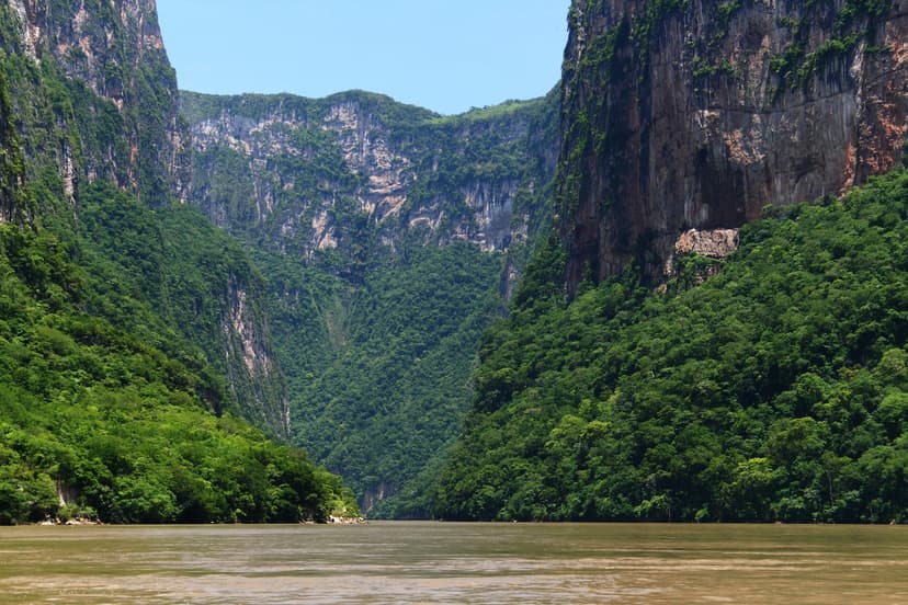
Sumidero Canyon
Sumidero Canyon is a deep natural canyon in Chiapas, southern Mexico, carved over millions of years by the Grijalva River. Its formation began concurrently with the Grand Canyon, shaped by tectonic crustal cracks and river erosion. The canyon is a significant natural landmark and a major tourist attraction, renowned for its towering vertical walls and unique geological formations, while also facing considerable environmental challenges.

Barranca de Oblatos
Barranca de Oblatos, also known as Barranca de Huentitán, is a significant canyon located in Jalisco, Mexico, carved by the Río Grande de Santiago. Its striking geological features bear a resemblance to the Grand Canyon and Barranca del Cobre, and it serves as a vital biogeographic corridor within the Guadalajara Metropolitan Area. The canyon is recognized as a protected ecological zone, hosting diverse flora and fauna, and has been a site of historical conflict and development.

Barron Gorge
Barron Gorge is a dramatic gorge located in Queensland, Australia, carved by the Barron River as it descends the eastern escarpment of the Atherton Tablelands. Renowned for its spectacular waterfalls, particularly the Barron Falls which cascade 265 meters, the gorge is a significant natural landmark within the Wet Tropics World Heritage Area. Historically important for Indigenous peoples and later for hydroelectric power generation, it is now a protected national park and a popular tourist destination.