
Mågålaupet Gorge
River Canyon·Norway·Driva·Gneiss
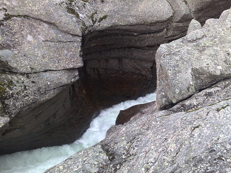
Mågålaupet Gorge is a striking 100-meter long, zigzag-shaped canyon carved by the river Driva in Oppdal Municipality, Norway. Its formation is attributed to the continuous erosion and the development of giant's kettles by the river since the last ice age, primarily in hard gneiss bedrock. The gorge is notable for its extreme narrowness, measuring just 1.5 meters at its tightest point.
Key Facts
- ›The gorge is approximately 100 meters (330 ft) in length.
- ›It is characterized by a zigzag shape.
- ›The narrowest point of the gorge is only 1.5 meters (4 ft 11 in) wide.
- ›Mågålaupet is formed by a series of interconnected giant's kettles.
- ›The bedrock in the gorge is composed of hard gneiss.
- ›It is located in the Drivdalen valley, Trøndelag county, Norway.
Magalaupet, Måggålaupet
River Erosion, Glacial Processes
Giant's Kettles, Zigzag Shape
About Mågålaupet Gorge
Mågålaupet Gorge, also known by variations such as Magalaupet and Måggålaupet, is a remarkable natural feature located in Oppdal Municipality, Trøndelag county, Norway. This distinctive canyon is carved into the landscape by the persistent flow of the river Driva, situated within the scenic Drivdalen valley. Approximately 12 kilometers south of the village of Oppdal, Mågålaupet presents a dramatic display of geological forces at work.
Geological Formation
The gorge is characterized by its 100-meter length and a striking zigzag pattern. Its formation is a testament to the erosive power of the river Driva, particularly since the end of the last ice age. The canyon is composed of a series of large, interconnected giant's kettles, which are smooth, bowl-shaped depressions formed by the swirling action of water and sediment. The bedrock of the gorge consists of hard gneiss, a durable metamorphic rock that has withstood the river's carving action over millennia. A particularly notable feature is the extreme narrowness of the gorge; at its most constricted point, Mågålaupet measures a mere 1.5 meters across, creating a dramatic and intimate experience for visitors.
Location and Significance
Mågålaupet Gorge is a significant natural landmark in the Trøndelag region, drawing attention for its unique geological formations and its dramatic scale. While not within a national park, its accessibility and striking features make it a point of interest for those exploring the natural beauty of Norway. The gorge serves as a vivid illustration of how rivers shape the land over vast periods, offering a glimpse into the dynamic geological history of the area.
Source: Wikipedia ↗
Frequently Asked Questions
What geological processes formed Mågålaupet Gorge?
Mågålaupet Gorge was formed by the river Driva since the last ice age. The primary process involves the river's erosion, which has created a series of large, interconnected giant's kettles along its course.
What type of rock is found in Mågålaupet Gorge?
The bedrock in Mågålaupet Gorge is primarily hard gneiss. This resilient rock type has been shaped by the relentless power of the river over millennia.
How narrow is Mågålaupet Gorge?
Mågålaupet Gorge is famously narrow, with its tightest point measuring just 1.5 meters (4 ft 11 in) wide. This extreme constriction is a defining characteristic of the canyon.
Where is Mågålaupet Gorge located?
Mågålaupet Gorge is situated in Oppdal Municipality, within Trøndelag county, Norway. It lies in the Drivdalen valley, approximately 12 kilometers south of the village of Oppdal.
What is the significance of the giant's kettles at Mågålaupet?
The gorge is characterized by a series of large, interconnected giant's kettles. These geological formations are a direct result of the river Driva's erosive action over a long period, showcasing the power of water in shaping the landscape.
Related Canyons

Fish River Canyon
The Fish River Canyon, located in southern Namibia, is the largest canyon in Africa and the second most visited tourist attraction in the country. This immense geological feature was primarily formed by river erosion over millions of years, with its current deep, meandering system shaped by continental drift and subsequent uplift of the African continent. It is renowned for its dramatic scale, challenging hiking trail, and the stark beauty of its arid landscape.

Mianus River Gorge
The Mianus River Gorge is a nature preserve in Bedford, New York, recognized as a National Natural Landmark for its old-growth hemlock forest and the gorge itself. Formed by streams during glacial retreat, the gorge showcases diverse bedrock types and is managed by Mianus River Gorge, Inc. in conjunction with The Nature Conservancy.

Sautso Canyon
Sautso Canyon, also known as Alta Canyon, is a prominent geological feature in Finnmark county, Norway, carved by the Altaelva river. Stretching approximately 12 kilometers and reaching depths of up to 420 meters, it holds the distinction of being the largest canyon in Northern Europe. Its formation showcases numerous sedimentary layers as the river descends from the Finnmarksvidda plateau.