
Monterey Canyon
Submarine Canyon·North America·Salinas River (prehistoric)
Monterey Canyon, also known as Monterey Submarine Canyon, is the largest submarine canyon on the West Coast of North America, located in Monterey Bay, California. It was primarily formed by turbidity current erosion and features steep walls rivaling the depth of the Grand Canyon. The canyon is a significant area of ongoing geological and marine life research due to questions surrounding its origins and immense scale.
Key Facts
- ›Rivals the Grand Canyon in depth with canyon walls measuring 1 mile (1.6 km) in height.
- ›Extends 95 miles (153 km) under the Pacific Ocean, reaching depths of up to 3,600 meters (11,800 ft).
- ›Formed by turbidity current erosion, a process of underwater sediment flow.
- ›Its immense size suggests it may be the remnant outlet of a larger prehistoric river system.
- ›Part of the greater Monterey Bay Canyon System, which includes Soquel and Carmel Canyons.
- ›The Soquel Canyon State Marine Conservation Area protects a side-branch of the canyon.
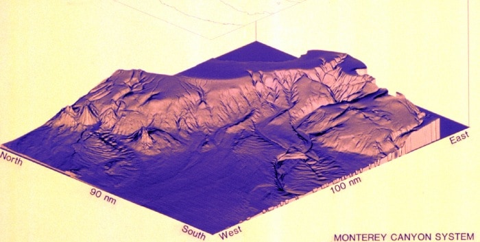
Monterey Submarine Canyon
Turbidity Current Erosion, River Erosion
Monterey Canyon Submarine Fan, Steep Canyon Walls
About Monterey Canyon
Monterey Canyon: A Colossal Submarine Landscape
Monterey Canyon, also referred to as Monterey Submarine Canyon, stands as the most extensive submarine canyon along the western coast of North America. Located within Monterey Bay, California, its sheer scale is remarkable, with canyon walls reaching a staggering 1 mile (1.6 km) in height, a dimension that rivals the colossal depth of the Grand Canyon. The formation of this immense underwater chasm is primarily attributed to turbidity current erosion, a powerful process involving the flow of sediment-laden water.
Geomorphology and Origins
The precise origins of Monterey Canyon's extraordinary depth and length, carved out millions of years ago, remain a subject of ongoing scientific inquiry. While turbidity current erosion is understood as the mechanism, the specific cause for its magnitude is debated. Typically, such deep and extensive submarine canyons are associated with the outflows of major rivers, like the Mississippi or Amazon. However, Monterey Canyon is not aligned with a comparably large modern river; the Salinas River is the closest significant watercourse, and it is theorized to have been the outlet for prehistoric Lake Corcoran. Reconstructions based on plate-tectonic theory suggest the canyon has migrated northwest due to the San Andreas Fault's action, implying it was once located much further south.
The immense sedimentary deposit, known as the Monterey Fan, found at the canyon's underwater mouth 95 miles (153 km) offshore, further fuels speculation. This fan is considered too massive to have been formed by modern coastal streams, suggesting a far greater past influx of sediment. Scientists are actively conducting research, including core sampling, to analyze ancient sedimentary layers and trace them back to their original sources. This work aims to resolve questions about which prehistoric river system might have provided the high volume of turbidity currents necessary to carve out such a profound and lengthy canyon and deposit such a vast amount of sediment.
Ecological Significance and Protection
Monterey Canyon is part of the larger Monterey Bay Canyon System, which also includes Soquel and Carmel Canyons. The canyon's considerable depth and the regular influx of nutrient-rich sediment create a vital habitat that supports a diverse array of marine life. A portion of this unique environment is recognized for its conservation value, with the Soquel Canyon State Marine Conservation Area protecting a side-branch of the Monterey Submarine Canyon, functioning much like an underwater park to safeguard marine ecosystems and wildlife.
Source: Wikipedia ↗
Frequently Asked Questions
How was Monterey Canyon formed?
Monterey Canyon was primarily formed by turbidity current erosion, which involves the flow of sediment-laden water down the canyon walls. Scientists are still investigating the exact causes for its great depth and length.
What is the size of Monterey Canyon?
The canyon walls reach a height of 1 mile (1.6 km), and the canyon extends 95 miles (153 km) under the Pacific Ocean, reaching depths of up to 3,600 meters (11,800 ft) at its mouth.
Why is Monterey Canyon significant?
It is the largest submarine canyon on the West Coast of North America and is a subject of ongoing geological and marine life studies. Its depth and nutrient availability also support a diverse range of marine life.
What are the theories about the origin of Monterey Canyon?
One dominant theory suggests it is the remnant outlet of a larger river that once drained the Central Valley, possibly moving northwest due to San Andreas Fault action. Research into sediment chemistry supports a southern Sierra Nevada or western Basin and Range origin.
Is Monterey Canyon a protected area?
A side-branch of Monterey Canyon is protected by the Soquel Canyon State Marine Conservation Area. This marine protected area aims to conserve ocean wildlife and marine ecosystems.
What is the Monterey Canyon submarine fan?
The Monterey Canyon submarine fan is a massive sedimentary deposit located at the downstream mouth of the canyon, 95 miles west of Monterey. Its large size is a key piece of evidence in the ongoing research into the canyon's origins.
Related Canyons
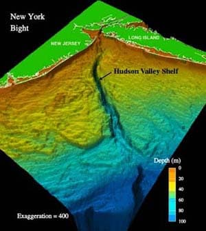
Hudson Canyon
The Hudson Canyon is a significant submarine canyon extending over 400 miles from the mouth of the Hudson River across the continental shelf. It plays a crucial role in transporting sediment from the river to the deep ocean basin and is also a navigational reference point for shipping entering New York Harbor. Its formation is primarily attributed to river erosion and subsequent oceanic processes.

Pribilof Canyon
Pribilof Canyon is a significant submarine canyon situated on the Bering Abyssal Plain in the Bering Sea, southeast of Alaska's Pribilof Islands. It acts as a crucial underwater geological feature, connecting to the larger Bering Canyon at its western extremity. Its formation and geological significance are tied to the dynamic processes shaping the ocean floor.

Avilés Canyon
The Avilés Canyon is a significant submarine canyon system located off the coast of Asturias, Spain, in the Cantabrian Sea. As part of the larger Avilés Canyon System, it extends for approximately 75 kilometers and plunges to depths of nearly 5 kilometers, positioning it among the deepest on the planet. This deep-sea environment is a recognized biodiversity hotspot, supporting a rich array of marine life, including various whale species, numerous starfish, and ancient cold-water coral reefs.