
San Rafael River Gorge
River Canyon·United States·San Rafael River·Coconino Sandstone
The San Rafael River Gorge is a significant geological feature in east central Utah, carved by the San Rafael River. This arid region of the Colorado Plateau is characterized by its isolated and scenic gorge, which includes narrow slot canyons and is sometimes referred to as the "Little Grand Canyon." The river itself is a tributary of the Green River and plays a role in irrigation for nearby counties.
Key Facts
- ›Flows through an arid region of the Colorado Plateau.
- ›Features two narrow slot canyons known as the Upper and Lower Black Box.
- ›The gorge is sometimes called the "Little Grand Canyon."
- ›The San Rafael River is approximately 90 miles (140 km) long.
- ›It is the last major tributary of the Green River before its confluence with the Colorado River.
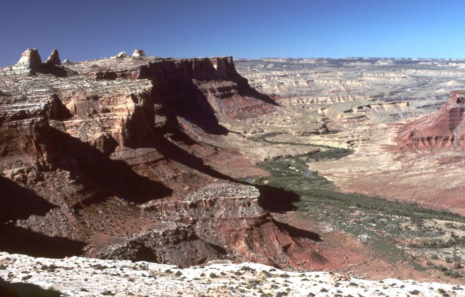
Little Grand Canyon
River Erosion
Upper and Lower Black Box Slot Canyons, San Rafael Swell, Window Butte, San Rafael Reef
About San Rafael River Gorge
The San Rafael River Gorge is a prominent geological formation located in east central Utah, United States. Carved by the San Rafael River, this gorge traverses a sparsely populated arid region of the Colorado Plateau, renowned for its isolated and scenic beauty. The river itself is approximately 90 miles (140 km) in length and serves as a tributary to the Green River.
Description and Geology
The gorge is characterized by its rugged terrain and includes two notable narrow slot canyons known as the Upper and Lower Black Box. These formations are carved into the Coconino Sandstone, showcasing the erosive power of the river over time. The area is sometimes referred to as the "Little Grand Canyon," highlighting its impressive, albeit smaller-scale, resemblance to more famous canyon systems.
Significance and Access
While not a national park, the San Rafael River Gorge is recognized as a significant natural landmark and a tourist attraction for those seeking to explore the unique landscapes of Utah. The San Rafael River plays a crucial role in the regional hydrology, with diversion tunnels at its headwaters in the Manti-La Sal National Forest providing essential irrigation water to Sanpete County. The river is the final major tributary to join the Green River before its confluence with the Colorado River within Canyonlands National Park, underscoring its ecological and geographical importance in the broader river system.
Source: Wikipedia ↗
Frequently Asked Questions
What is the San Rafael River Gorge known for?
The San Rafael River Gorge is known for its isolated and scenic canyon through which the San Rafael River flows. It includes dramatic slot canyons and is often referred to as the "Little Grand Canyon" due to its rugged beauty.
Where is the San Rafael River Gorge located?
The San Rafael River Gorge is located in east central Utah, United States, across a sparsely populated arid region of the Colorado Plateau. The river rises in northwestern Emery County and flows eastward.
What geological features are found in the San Rafael River Gorge?
The gorge is characterized by its arid landscape and includes two notable narrow slot canyons called the Upper and Lower Black Box. These canyons are carved into Coconino Sandstone.
What is the significance of the San Rafael River?
The San Rafael River is a 90-mile-long tributary of the Green River. Diversion tunnels at its headwaters provide irrigation water to Sanpete County, and it is the last major tributary of the Green River before its confluence with the Colorado River.
Related Canyons

Canyons of the Escalante
The Canyons of the Escalante are a vast network of erosional landforms in southern Utah, carved by the Escalante River and its tributaries. These sandstone canyons feature high vertical walls, numerous slot canyons, waterpockets, natural arches, and hoodoos. The area is a significant part of the Grand Staircase–Escalante National Monument and the Glen Canyon National Recreation Area, renowned for its geological history and dramatic landscapes.

Cheat Canyon
Cheat Canyon, also known as Cheat River Canyon or Cheat River Gorge, is a significant forested gorge carved by the Cheat River in West Virginia. Extending approximately 10.5 miles, it is renowned for its challenging whitewater rapids, attracting paddlers for events like the Cheat Festival and The Cheat River Race. The canyon's preservation has been a subject of ongoing debate between environmental activists and development interests, particularly concerning its rich biodiversity and flood risk.

Columbia River Gorge
The Columbia River Gorge is a significant canyon carved by the Columbia River as it flows westward through the Cascade Range, forming the boundary between Washington and Oregon. This 130 km (80 mile) long and up to 1,200 m (4,000 ft) deep water gap is the sole navigable route through the Cascades and the only water connection between the Columbia Plateau and the Pacific Ocean. It is a popular recreational destination and federally protected as the Columbia River Gorge National Scenic Area.