
Ritacuba Blanco
Glacier·Colombia·South America·Alpine
Ritacuba Blanco is the highest peak in Colombia's Cordillera Oriental, part of the Andes Mountains. It is significant as the location of a rapidly melting glacier, which serves as a stark indicator of global warming's impact on tropical mountains. The peak is accessible for climbing, though its glacier is a notable feature for those who ascend it.
Key Facts
- ›Ritacuba Blanco is the highest summit in the Cordillera Oriental of the Andes in Colombia.
- ›The mountain is also known by its ancient U'wa indigenous name, Ritak'uwa.
- ›Its glacier has been observed to be retreating at an alarming rate of 25 linear meters per year.
- ›The glacier's lowest point has risen significantly, from 4,100 meters in 1950 to 4,500 meters in 2007.
- ›If current melting trends persist, the glacier is projected to vanish before the year 2055.
- ›The normal climbing route from the northwest is considered technically easy, requiring basic mountaineering knowledge.
Known For
- Highest peak in Colombia's Cordillera Oriental
- Rapidly melting glacier as an indicator of climate change
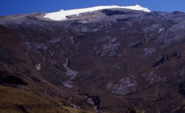
Ritacuba Blanco Glacier
- National Park Sierra Nevada Del Cocuy Y GüIcáN
About Ritacuba Blanco
Ritacuba Blanco stands as the highest peak within Colombia's Cordillera Oriental, a prominent section of the Andes Mountains. The mountain is also recognized by its ancient name, Ritak'uwa, a designation used by the U'wa indigenous people who inhabit the regions surrounding the National Park Sierra Nevada del Cocuy y Güicán, where Ritacuba Blanco is located.
Climate Change Indicator
The glacier atop Ritacuba Blanco is a critical subject of study due to its rapid recession attributed to global warming. Historical data shows a significant retreat: in 1950, the glacier extended down to 4,100 meters (13,500 ft) above sea level, but by January 2007, its lowest point had risen to 4,500 meters (14,800 ft). This glacier is backing down at an estimated rate of 25 linear meters per year, mirroring the dramatic melting occurring on other tropical mountain snowcaps across Colombia.
Accessibility and Climbing
Ascending Ritacuba Blanco is possible, with access routes originating from the towns of El Cocuy and Güicán in the Boyacá department. After traveling to Kanwara, the primary hike towards the mountain's base commences. While the normal northwest climbing route is considered technically easy, requiring only basic mountaineering knowledge, the unpredictable weather conditions pose a challenge. A glacier must be traversed as part of the ascent. The eastern climbing route, though closed, is noted for its significant challenges for big wall climbers.
Future Outlook
If the current rate of glacial melt continues unabated, projections indicate that the glacier on Ritacuba Blanco could cease to exist before the year 2055. This stark prediction highlights the vulnerability of high-altitude glacial environments to climate change.
Source: Wikipedia ↗
Frequently Asked Questions
What is Ritacuba Blanco?
Ritacuba Blanco is the highest peak in the Cordillera Oriental of the Andes Mountains in Colombia. It is also known by the ancient U'wa indigenous name, Ritak'uwa.
Where is Ritacuba Blanco located?
Ritacuba Blanco is situated within the National Park Sierra Nevada del Cocuy y Güicán, in the Boyacá department of Colombia.
What is significant about Ritacuba Blanco's glacier?
The glacier on Ritacuba Blanco is a key indicator of global warming's effects on tropical mountains. It is melting at a very high rate, retreating approximately 25 linear meters per year.
What is the expected future of Ritacuba Blanco's glacier?
Due to the rapid melting rate, the glacier on Ritacuba Blanco is expected to disappear before 2055 if current trends continue. This phenomenon is also occurring on other snow-covered tropical mountains in Colombia.
How can one access Ritacuba Blanco?
Access to Ritacuba Blanco is typically from the towns of El Cocuy or Güicán in the Boyacá department. After reaching Kanwara, the main hike to the base of the mountain begins. A glacier must be crossed to reach the summit.
Related Glaciers

Nevado del Ruiz
Nevado del Ruiz is a stratovolcano in Colombia that is the highest point in both the Caldas and Tolima departments. It is part of the Andes mountain range and is known for its glaciers and its history of devastating lahars, particularly the 1985 eruption that destroyed the town of Armero and caused an estimated 25,000 deaths, making it the deadliest lahar in recorded history.

Sierra Nevada de Santa Marta
The Sierra Nevada de Santa Marta is an isolated mountain range in northern Colombia, distinct from the Andes. It is the highest coastal range in the tropics, with its peaks reaching nearly 5,700 meters and lying just 42 kilometers from the Caribbean coast. This range is a crucial ecological hub, housing diverse ecosystems and serving as the source of 36 rivers that supply water to approximately 1.2 million people.

Amalia Glacier
Amalia Glacier, also known as Skua Glacier, is a tidewater glacier situated in Bernardo O'Higgins National Park, Chile. Originating from the Southern Patagonian Ice Field, it is notable for its significant retreat between 1945 and 1986, which was among the most dramatic observed in the region during that period. The glacier also plays a role in shaping the landscape by partially surrounding and eroding the northern flank of the Reclus volcano.