
Bullenkuhle
dissolution·Germany·Rock salt (leaching from underground salt domes)
The Bullenkuhle is a protected marshy lake and sinkhole located in the north German state of Lower Saxony. It is a geologically significant feature, formed by the dissolution of underground salt deposits leading to surface collapse. The sinkhole is notable for its unique 'quaking bog' ecosystem and diverse flora and fauna, including rare plant species and amphibians.
Key Facts
- ›The Bullenkuhle is a sinkhole that has formed into a marshy lake.
- ›It is located in the district of Gifhorn, Lower Saxony, Germany.
- ›The sinkhole has a diameter of approximately 130 meters and a depth of 15 meters.
- ›Its formation is attributed to the leaching of underground salt domes from the Permian period.
- ›The area is environmentally protected and features a 'quaking bog' ecosystem.
- ›It is populated by typical marsh plants, including rare species like the Dwarf White Water Lily.
Quaking Bog, Marshy Lake, Steep-Sided Hollow
Oligotrophic, Humus-Rich, Moderately Acidic
Peat Mosses, Bladderworts, Dwarf White Water Lily, Hare's-Tail Cottongrass, Cross-Leaved Heath, Common Heather, Crowberry, White Beak-Sedge, Cranberry, Bottle Sedge, Bilberry, Purple Moor Grass, Juniper, Birch Trees, Buckthorn Bushes, Pines, Amphibians, Adders
About Bullenkuhle
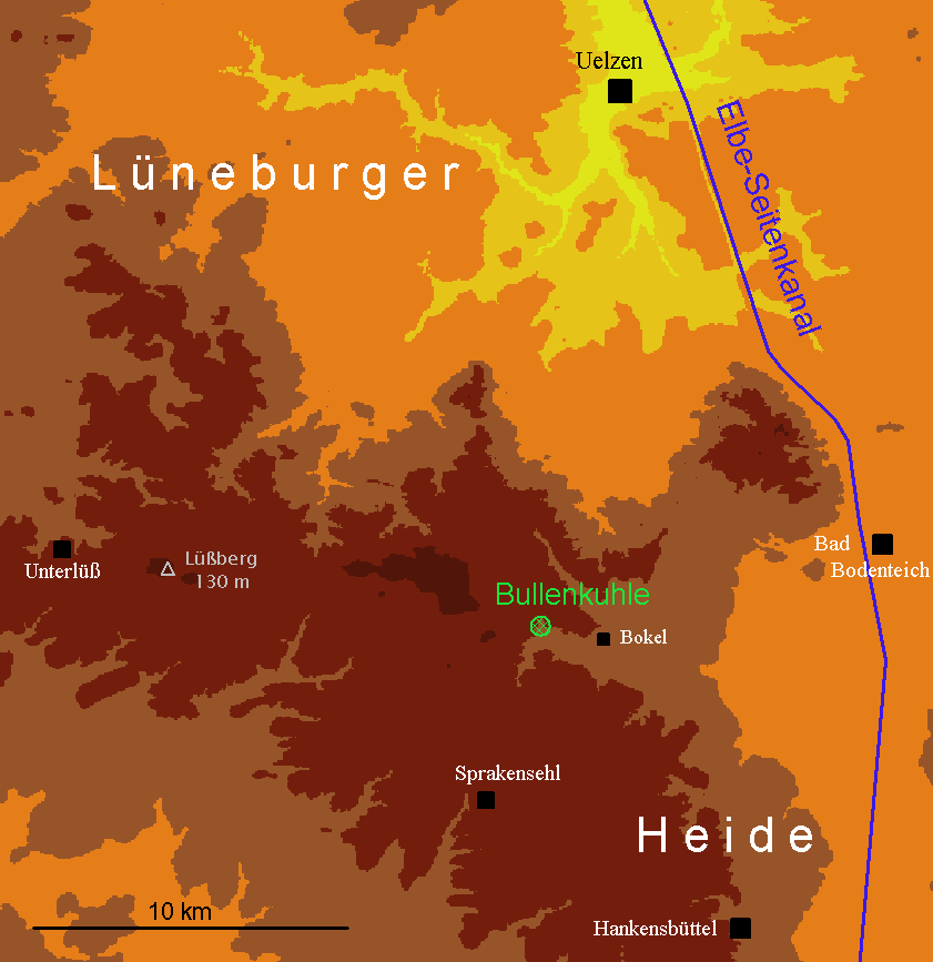
The Bullenkuhle is a distinctive natural sinkhole located in the northern German state of Lower Saxony, characterized by its marshy lake and protected status as a biotope and geotope. This geological formation is situated in the district of Gifhorn, approximately 15 kilometers south of the town of Uelzen and a short distance west of the village of Bokel. Its unique landscape is a result of subterranean geological processes and harbors a rich and specialized ecosystem.
Geological Formation
The Bullenkuhle's formation is attributed to the dissolution of underground salt domes, which are remnants from the Permian period's Zechstein Sea. When rock salt encounters groundwater, it leaches away, potentially creating large caverns. The subsequent collapse of these caverns can lead to the ground surface caving in, forming prominent, often steep-sided hollows known as sinkholes. While the exact timing of the Bullenkuhle's formation is not precisely documented, sinkholes are geologically often recent, with many dating back only a few hundred or thousand years.
Description and Ecology
The sinkhole presents as a basin-shaped hollow with slopes ranging from 30 to 60 degrees. At its base, a marsh covers about 0.5 hectares, which is identified as a 'quaking bog' or 'Schwingrasen.' This bog features a floating mat of moss and other vegetation, with evidence suggesting that beneath it lies water rather than a continuous layer of peat. Approximately 80% of this wetland is covered by the floating mat, with a small stretch of open, deep water, a bog pond, existing in the northeast. The water is characterized as very oligotrophic, humus-rich, and moderately acidic, supporting a variety of marsh plants, including peat mosses, bladderworts, and the rare Dwarf White Water Lily.
The bog pond's periphery is surrounded by a ring-shaped bog that receives slightly more nutrients from surface runoff. The slopes of the sinkhole are covered with low vegetation such as Common Heather, Bilberry, and Cranberry, alongside grasses and trees, including notably large and old Juniper bushes. The fauna is diverse, with up to eight species of amphibians and adders being notable inhabitants of this marsh biotope.
Location and Landscape Context
The Bullenkuhle is situated within the southeastern fringes of the Hohen Heide, part of the Lüneburg Heath. This landscape was geomorphologically shaped by the edges of the ice sheet during the Saalian glaciation. The surrounding terrain consists of end and ground moraines, with pine forests typically covering the undulating ridges and agricultural use characterizing the ground moraines. While the classic heath landscape of Lüneburg Heath exists today only in fragments, the area around the Bullenkuhle is a testament to its natural geological and ecological processes.
Source: Wikipedia ↗
Frequently Asked Questions
What is the Bullenkuhle?
The Bullenkuhle is a natural hollow in the terrain, classified as a sinkhole, which has developed into a predominantly marshy lake. It is an environmentally protected biotope and geotope in Lower Saxony, Germany.
How was the Bullenkuhle formed?
The sinkhole was formed by the dissolution of underground salt domes, a relic from the Permian period's Zechstein Sea. When rock salt comes into contact with groundwater, it leaches away, creating caverns that can collapse, leading to the ground caving in and forming sinkholes.
What are the dimensions of the Bullenkuhle?
The Bullenkuhle has a diameter of approximately 130 meters and reaches a maximum depth of 15 meters. The marshy area itself covers about 0.5 hectares.
What is special about the Bullenkuhle's ecosystem?
The Bullenkuhle features a unique 'quaking bog' (Schwingrasen or Schwingmoor), which is a floating mat of moss and plants. This bog is very oligotrophic, moderately acidic, and hosts typical marsh plants like peat mosses, bladderworts, and the rare Dwarf White Water Lily.
What kind of wildlife can be found at the Bullenkuhle?
The animal world at the Bullenkuhle is noteworthy, with species peculiar to marsh biotopes. It is known to host up to eight species of amphibians and adders.
Where is the Bullenkuhle located?
The Bullenkuhle is situated in the extreme north of the district of Gifhorn in the north German state of Lower Saxony. It lies about 15 kilometers south of the town of Uelzen and a kilometer west of the village of Bokel.
Is the Bullenkuhle a tourist attraction?
While the area is environmentally protected, its unique geological and ecological features likely make it of interest to nature enthusiasts. Specific details about its development as a formal tourist attraction are not provided.
Related Sinkholes

Danube Sinkhole
The Danube Sinkhole is a natural phenomenon in Germany where the Danube River's water disappears underground into a karst system, reappearing miles away as the source of the Radolfzeller Aach. This incipient underground stream capture is geologically significant as it demonstrates a dynamic hydrological process that diverts a portion of the Danube's flow into the Rhine watershed, highlighting a major European watershed boundary.

Big Basin Prairie Preserve
The Big Basin Prairie Preserve in Kansas encompasses a significant sinkhole system, most notably the mile-wide Big Basin and the water-filled St. Jacob's Well. These geological features, formed by sinkhole activity, are historically notable as resting places for the Northern Cheyenne and landmarks for cattle drives. The preserve is a designated National Natural Landmark, managed to protect its unique landscape and wildlife.

Blue Lake
Blue Lake is a significant karst sinkhole located near Imotski, Croatia. It is known for its dramatic seasonal water level fluctuations and its considerable depth, potentially formed by the collapse of a large cave. The lake is a popular site for tourism and outdoor activities.