
Barron River (Ontario)
River Canyon·Canada·Petawawa River·Canadian Shield rocks
The Barron River is a significant waterway in Ontario, Canada, flowing through Algonquin Provincial Park and forming the southern branch of the Petawawa River. It was primarily formed by glacial meltwater approximately 10,000 years ago, carving out the impressive Barron Canyon. Historically, it served as a crucial route for timber transport, with the canyon's towering cliffs known as the "Capes" by loggers.
Key Facts
- ›Flows from Clemow Lake in Algonquin Provincial Park to the Petawawa River.
- ›The Barron Canyon, a notable feature, is approximately 100 meters deep.
- ›Formed by glacial meltwater around 10,000 years ago.
- ›Rocks exposed in the canyon are part of the Canadian Shield.
- ›Historically used for timber transport, with loggers calling the cliffs the "Capes".
- ›Partially protected by Barron River Provincial Park, established in 2006.
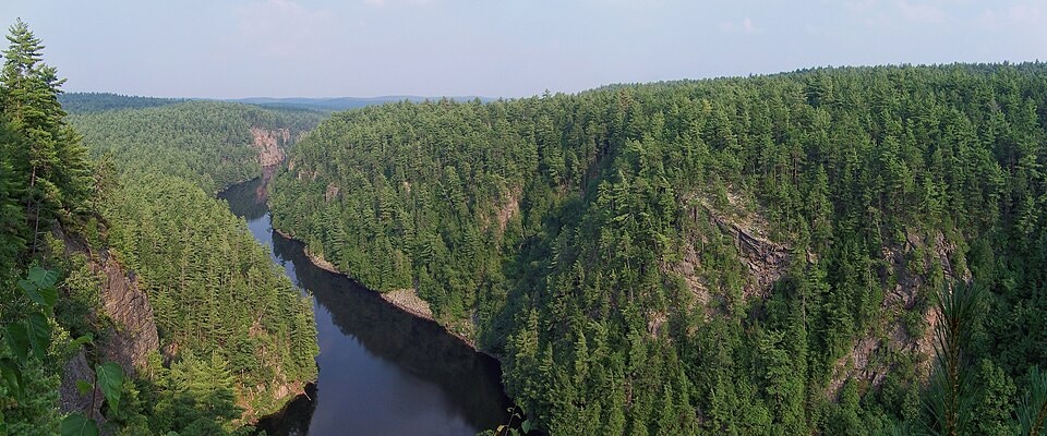
rivière Barron
Glacial Meltwater Erosion
Barron Canyon, High Falls, Cache Rapids, Squirrel Rapids, Cliffs Known As the "Capes"
Red and White Pine Forests, Subarctic Plants In Canyon Microclimate
About Barron River (Ontario)
Barron River
The Barron River, known in French as the rivière Barron, is a notable waterway located in Ontario, Canada, flowing through the Saint Lawrence River drainage basin. It originates from Clemow Lake in the northern section of Algonquin Provincial Park and eventually merges with the Petawawa River, forming its southern branch. This river is recognized for its scenic beauty, particularly the Barron Canyon, and its historical importance as a route for timber transport.
Geography and Geology
The river's journey begins in Clemow Lake, within the Unorganized South Nipissing District, and winds southeast through Grand Lake. It passes by sites like the Achray campground and crosses the path of a former railway line. After taking in tributaries such as Carcajou Creek, it flows over the Grand Lake Dam and continues through Stratton Lake. The river then turns northeast, passing High Falls and Brigham Chute, before entering Master Township and navigating the Cache Rapids and Squirrel Rapids. The final stretch sees the Barron River exit Algonquin Park and Nipissing District, entering Renfrew County, where it becomes part of Barron River Provincial Park along its southern bank. The river empties into Lac du Bois Dur on the Petawawa River, a short distance west of Black Bay and before reaching the municipality of Petawawa.
Geologically, the Barron River's most striking feature, the 100-meter-deep Barron Canyon, was carved by glacial meltwater approximately 10,000 years ago. This period saw the river acting as a primary outlet for meltwater, potentially carrying outflow from Lake Agassiz. The exposed rocks within the canyon are part of the ancient Canadian Shield, and the area still exhibits geological activity through rockfalls and landslides. The river's course is also situated within a fault line linked to the Ottawa-Bonnechere Graben.
History and Conservation
Historically, the Barron River was a vital artery for the timber industry in the late 19th and early 20th centuries. Its water levels were managed to aid in the transport of logs down to the Ottawa River. The steep cliffs of the Barron Canyon were dubbed the "Capes" by loggers, and the spring log drives were often boisterous affairs. The perilous nature of this work is still commemorated by graves found along the riverbanks. In recognition of its ecological and recreational value, Barron River Provincial Park was established in 2006. This non-operating park protects a significant water route and features the eastern portion of the Barron Canyon, which supports a unique microclimate hosting subarctic plant species within its crevices, while its clifftops are adorned with red and white pine forests. The park is open for activities such as boating, canoeing, fishing, and hunting.
Source: Wikipedia ↗
Frequently Asked Questions
How was the Barron Canyon formed?
The Barron Canyon was formed approximately 10,000 years ago by glacial meltwater. During this period, the river served as a main outlet for meltwater, and it is believed to have briefly carried outflow from Lake Agassiz.
What is the geology of the Barron River area?
The rocks exposed in the Barron Canyon are part of the Canadian Shield. The river itself lies within a fault associated with the Ottawa-Bonnechere Graben, and the canyon still experiences geological activity like rockfalls and landslides.
What activities are possible along the Barron River?
The Barron River is a popular canoe route, and a hiking trail leads to the edge of the Barron Canyon. Barron River Provincial Park, which protects a portion of the river, permits boating, canoeing, fishing, and hunting.
Is the Barron River accessible for recreation?
Yes, the Barron River is accessible for recreation. A popular canoe route passes through it, and a hiking trail leads to the Barron Canyon. Barron River Provincial Park offers opportunities for boating, canoeing, fishing, and hunting.
What is the historical significance of the Barron River?
The river was an important highway in the late 19th and early 20th centuries for transporting timber to the Ottawa River. Loggers referred to the towering cliffs of the Barron Canyon as the "Capes," and the river witnessed dangerous log drives.
Related Canyons

Agawa Canyon
Agawa Canyon is a shallow canyon in Ontario, Canada, formed approximately 1.2 billion years ago by faulting and later carved by the Agawa River. It is now a popular tourist destination within the Agawa Canyon Wilderness Park, accessible by train or hiking trail, and is renowned for its natural beauty, waterfalls, and seasonal foliage.

Coaticook Gorge
The Coaticook Gorge is a prominent natural feature located in Coaticook, Quebec, within the Estrie region of Canada. Carved by the Coaticook River, this gorge is characterized by its significant depth and length, making it a notable geological site in the area. Its formation is attributed to the erosive power of the river over time.

Coquihalla Canyon
Coquihalla Canyon is a provincial park in southwestern British Columbia, Canada, renowned for its dramatic gorge carved by the Coquihalla River. The canyon features the historic Othello Tunnels, a series of former railway tunnels that are now a popular recreational attraction. Its formation is attributed to the erosive power of the river acting upon granite batholiths, resulting in steep, fragmented walls and a narrow gorge.