
Bass Canyon
Submarine Canyon·Australia·Sandstone, Siltstone, Mudstone (sedimentary)
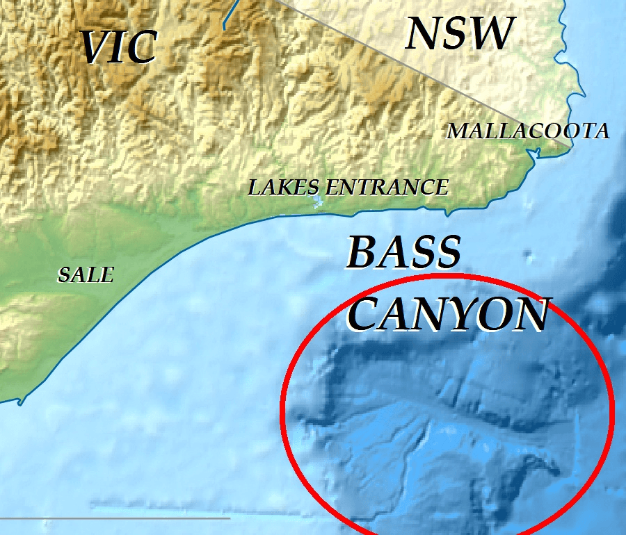
Bass Canyon is a vast submarine canyon system located off the coast of eastern Victoria, Australia, in Bass Strait. It is one of the deepest and largest submarine canyons globally, extending over 160 kilometers and reaching depths exceeding 3,000 meters. Its formation is attributed to complex erosional processes involving sediment gravity flows and tectonic activity, with evidence suggesting it has evolved over millions of years.
Key Facts
- ›Extends approximately 160 kilometers in length.
- ›Averages about 10 kilometers in width.
- ›Descends to depths exceeding 3,000 meters, with a floor at 3,000–4,000 meters.
- ›Fed by at least eight tributary canyons, including the large Everard Canyon.
- ›The canyon floor is composed of unconsolidated recent quartz sand, silts, and mud.
- ›Contains numerous subcircular, crater-like features interpreted as vents.
River Erosion, Sediment Gravity Flows, Tectonic Activity
Everard Canyon, Network of Tributary Channels, Flat Floor At 3,000–4,000 Meters, Subcircular, Crater-Like Features, Tasman Basin Proximity
Deep Sea Fish, Bathysaurus Mollis, Bathypterois Grallat, Acanthonus Armatus, Halieutaea, Squalus, Ateleopodidae, Chimaeridae, Crinoidea, Grimpoteuthis, Halosaur, Cosmopolitan Foraminifera
About Bass Canyon
Bass Canyon is a significant submarine canyon system located off the coast of eastern Victoria, Australia, within Bass Strait. It is recognized as one of the deepest and largest submarine canyons globally, a testament to the powerful erosional forces that have shaped the ocean floor over geological time.
Description and Geology
The canyon is a long and relatively narrow feature, extending approximately 160 kilometers with an average width of about 10 kilometers. It descends to impressive depths, with its floor situated between 3,000 and 4,000 meters. The canyon is fed by a complex network of at least eight tributary channels, including the substantial Everard Canyon, which originate from the Australian continental shelf and slope. The canyon floor is primarily composed of unconsolidated recent quartz sand, silts, and mud.
The geological composition of Bass Canyon's walls includes sedimentary rocks such as calcilutite and calcarenite, indicating deposition through mass-wasting events and debris flows. Seismic data and bathymetry reveal intricate canyon-fill forms and numerous subcircular depressions on the canyon floor, some of which are interpreted as fluid seeps or vents, potentially linked to underlying fault systems.
Formation and History
The precise age of Bass Canyon is a subject of ongoing research and debate. Erosional features suggesting its formation have been dated to the late Pliocene, with older, infilled canyon systems preserved in sediments dating back to the late Oligocene and becoming widespread from the Middle Miocene onward. Some theories propose its origins could be as ancient as the Tasman Sea breakup around 80 million years ago. The canyon's development is understood to be a result of downslope erosion by sediment gravity flows initiated at the shelf edge, progressively evolving into its current dendritic form. Tectonic events, such as a faulting event around 22 million years ago, likely played a role in shaping the canyon, particularly by eroding poorly consolidated sediments.
Exploration and Significance
Bass Canyon was first documented in 1968 through bathymetric soundings by the Royal Australian Navy Hydrographic Office. Modern sediment sampling and analysis began in the 1980s. Recent scientific expeditions, including a 2025 voyage of the CSIRO research vessel Investigator, have utilized advanced sonar mapping and visual imaging to study the canyon and its unique ecosystem. Despite temperatures hovering just above freezing, the canyon sustains a remarkable diversity of rarely observed deep-sea organisms, making it a crucial site for understanding deep-sea biodiversity and geological processes. Its location near the Tasman Basin and its complex geological structure also make it significant for studies of paleoceanography and basin evolution.
Source: Wikipedia ↗
Frequently Asked Questions
Where is Bass Canyon located?
Bass Canyon is situated off the coast of eastern Victoria, Australia, within Bass Strait. It lies approximately 90 kilometers southeast of Ninety Mile Beach, near Lakes Entrance.
How deep is Bass Canyon?
Bass Canyon descends to depths exceeding 3,000 meters, with its floor typically found between 3,000 and 4,000 meters. This makes it one of the deepest submarine canyons off the Australian coast.
What is the geology of Bass Canyon?
The canyon floor is composed of unconsolidated recent quartz sand, silts, and mud. Its walls are formed by sedimentary rocks, including calcilutite and calcarenite, with evidence of mass-wasting processes and debris flows.
What geological processes formed Bass Canyon?
Bass Canyon is thought to have been formed by erosional processes involving sediment gravity flows, particularly from its tributary channels originating on the continental shelf. Tectonic activity and uplift events have also contributed to its development over millions of years.
What is notable about the wildlife in Bass Canyon?
Despite the near-freezing temperatures, Bass Canyon supports a remarkable diversity of rarely observed deep-sea organisms. These include various deep-sea fish and invertebrates, with foraminiferal assemblages showing a mix of cosmopolitan and semi-endemic species.
When was Bass Canyon first documented?
Bass Canyon, along with its tributary Everard Canyon, was first documented in 1968. This documentation was based on bathymetric soundings collected by the Royal Australian Navy Hydrographic Office.
Related Canyons

Avilés Canyon
The Avilés Canyon is a significant submarine canyon system located off the coast of Asturias, Spain, in the Cantabrian Sea. As part of the larger Avilés Canyon System, it extends for approximately 75 kilometers and plunges to depths of nearly 5 kilometers, positioning it among the deepest on the planet. This deep-sea environment is a recognized biodiversity hotspot, supporting a rich array of marine life, including various whale species, numerous starfish, and ancient cold-water coral reefs.

Bering Canyon
Bering Canyon is the longest submarine canyon in the Bering Sea, stretching approximately 400 km across the continental shelf and slope. It is bordered by the Aleutian Islands to the east and culminates in a submarine channel-lobe system at the Aleutian Basin. Its immense length gives it the largest area among the Bering Sea canyons, despite being narrower at the shelf break than some others.
Congo Canyon
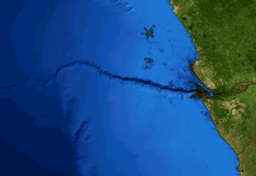
Congo Canyon is an immense submarine canyon located at the terminus of the Congo River in Africa, ranking among the largest of its kind globally. Its formation is primarily driven by powerful turbidity currents originating from the Congo River's outflow, which act as underwater avalanches, eroding the canyon and transporting vast amounts of sediment to the Congo Deep-Sea Fan. This process prevents delta formation and contributes to one of the world's largest active submarine fan systems.