
Bighorn Canyon
River Canyon·North America·Bighorn River
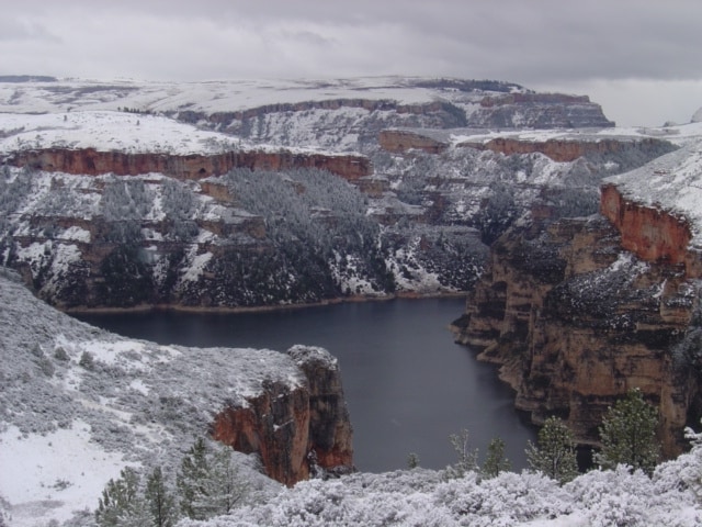
Bighorn Canyon National Recreation Area is a protected area straddling the border of Wyoming and Montana, established in 1966 following the construction of the Yellowtail Dam. The dam harnesses the Bighorn River, creating Bighorn Lake, which offers extensive recreational opportunities and flows through a significant portion of the canyon. The area preserves a rich history, with evidence of human habitation dating back 12,000 years and a significant cultural connection to the Crow people.
Key Facts
- ›Spans 120,296.22 acres across Wyoming and Montana.
- ›Bighorn Lake, formed by Yellowtail Dam, extends 71 miles (114 km).
- ›The recreation area is divided into two districts: North (Fort Smith, MT) and South (Lovell, WY).
- ›Archaeological evidence suggests human presence in the area for at least 12,000 years.
- ›Contains seven designated campgrounds and fifteen hiking trails.
- ›Offers diverse fishing opportunities for species like rainbow trout, smallmouth bass, and walleye.
River Erosion, Dam Construction
Bighorn Lake, Yellowtail Dam, Bad Pass Trail, Four Historic Ranches, Triple Echo Phenomenon
Bighorn Sheep, Black Bear, Mule Deer, Mountain Lions, Pronghorn, Coyotes, Beavers, Marmots, Black-Tailed Prairie Dog, Swift Fox, Northwestern Wolf, Various Bird Species, Rainbow Trout, Brown Trout, Smallmouth Bass, Channel Catfish, Ling, Walleye, Largemouth Bass, Sauger, Shovelnose Sturgeon, Crappie, Yellow Perch, Pumpkinseed, Stonecat, Carp
ApsáAlooke, Absarokaa
About Bighorn Canyon
Bighorn Canyon National Recreation Area
Bighorn Canyon National Recreation Area is a vast protected landscape spanning 120,296.22 acres across the border of Wyoming and Montana. Established on October 15, 1966, its creation was intrinsically linked to the construction of the Yellowtail Dam by the Bureau of Reclamation. This dam impounds the Bighorn River, forming the expansive Bighorn Lake, which stretches 71 miles (114 km) through the region and is a central feature for recreation.
The recreation area is managed by the U.S. National Park Service and is divided into two primary districts: the North District, accessed via Fort Smith, Montana, and the South District, reached through Lovell, Wyoming. Notably, there is no direct road connecting these two districts within the recreation area itself.
Geological and Historical Context
The canyon's formation is a testament to the enduring power of river erosion, with the Bighorn River carving its path over geological time. The subsequent construction of the Yellowtail Dam transformed the natural canyon into a significant reservoir, creating a unique environment for both nature and human activities. Archaeological findings indicate human presence in the area dating back as far as 12,000 years ago. The Crow people, or Apsáalooke, migrated to this region around the 16th century and established it as their territory, engaging in both conflict and cooperation with other tribes and the U.S. government. The canyon holds cultural significance for the Crow, who initially opposed the dam's construction due to its sacred status, though negotiations eventually led to the dam's creation and its naming in honor of Crow leader Robert Yellowtail.
Recreation and Ecology
Bighorn Lake provides extensive opportunities for visitors, including boating, fishing, water skiing, kayaking, and birding. The recreation area boasts seven designated campgrounds and fifteen hiking trails, offering diverse ways to explore the landscape. The waters below the Yellowtail Dam have transitioned into a cold tailwater fishery, renowned for rainbow and brown trout, while the reservoir supports species such as smallmouth bass, channel catfish, and walleye. The diverse habitats within the recreation area support a rich ecosystem, home to numerous bird species, as well as mammals like bighorn sheep, black bears, mule deer, and pronghorn. The area also includes notable features such as four historic ranches and the curious phenomenon of a "triple echo" phenomenon near Lovell.
Access and Facilities
Visitor services are available in both districts. The Cal S. Taggart Visitor Center in Lovell, Wyoming, serves the South District and is generally open year-round, with some seasonal closures. The Yellowtail Dam Visitor Center in Fort Smith, Montana, is currently closed, as is its access road. Marinas in both districts, Ok-A-Beh Marina in the North and Horseshoe Bend Marina in the South, facilitate boating access to Bighorn Lake.
Source: Wikipedia ↗
Frequently Asked Questions
What geological processes formed Bighorn Canyon?
While the article text focuses on the creation of Bighorn Lake by the Yellowtail Dam, the canyon itself was formed by the erosive power of the Bighorn River over millennia. The damming of the river transformed the natural canyon into a reservoir.
What recreational activities are available at Bighorn Canyon?
Visitors can enjoy a variety of activities on Bighorn Lake, including recreational boating, fishing, water skiing, kayaking, and birding. The area also offers camping, hiking, and hunting in designated zones.
How can I access Bighorn Canyon?
Bighorn Canyon National Recreation Area has two distinct districts. The North District is accessed via Fort Smith, Montana, and the South District is accessed through Lovell, Wyoming. There is no connecting road between the two districts within the recreation area.
What is the significance of Yellowtail Dam?
Yellowtail Dam was constructed by the Bureau of Reclamation to harness the waters of the Bighorn River. It created Bighorn Lake, a major recreational feature of the area, and is named after Robert Yellowtail, a prominent Crow leader who advocated for the tribe's land rights.
What kind of wildlife can be found in Bighorn Canyon?
Bighorn Canyon provides habitat for a wide array of wildlife, including at least 231 species of birds, as well as bighorn sheep, black bears, mule deer, mountain lions, pronghorn, coyotes, beavers, and marmots. Species of Concern like the black-tailed prairie dog and swift fox also inhabit the area.
Is Bighorn Canyon a national park?
Bighorn Canyon is a National Recreation Area managed by the U.S. National Park Service, rather than a national park. It is one of over 420 sites managed by the agency.
Related Canyons

Bad Rock Canyon
Bad Rock Canyon is a river canyon located east of Columbia Falls, Montana, through which the Flathead River flows. Historically, it served as a significant buffalo trail for various indigenous tribes and later became a gateway to wilderness areas like the Bob Marshall Wilderness and Glacier National Park. The canyon is also known for frequent rock slides that impact the adjacent BNSF Railway tracks.

Big Bend National Park
Big Bend National Park is a vast protected area in West Texas, notable for its extensive Chihuahuan Desert topography and ecology. Formed by the erosive power of the Rio Grande and significant geological uplift, the park preserves a rich tapestry of life, including over 1,200 plant species and hundreds of animal species, as well as ancient fossils and diverse rock formations. Its remote location and dramatic landscapes, including the Chisos Mountains and deep river canyons, make it a significant destination for naturalists and adventurers.
Big South Fork of the Cumberland River
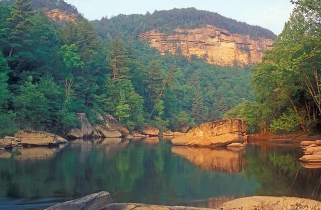
The Big South Fork of the Cumberland River is a significant river system in Tennessee and Kentucky, carved into the Cumberland Plateau. This 76-mile waterway is characterized by rugged terrain with deep gorges, natural arches, and rock shelters, and is the central feature of the Big South Fork National River and Recreation Area. Its formation by river erosion has created a diverse ecosystem and a popular destination for outdoor recreation.