
Blue Nile
River Canyon·Africa·Nile
The Blue Nile is a major river originating from Lake Tana in Ethiopia, flowing for approximately 1,450 km through Ethiopia and Sudan before joining the White Nile. It is the primary source of water for the Nile River, supplying about 85.6% of its flow during the rainy season and playing a crucial role in the fertility of the Nile Valley and the development of Ancient Egypt.
Key Facts
- ›Originates at Lake Tana in Ethiopia and flows for approximately 1,450 km through Ethiopia and Sudan.
- ›Supplies about 85.6% of the water to the Nile River during the rainy season.
- ›Flows through virtually impenetrable gorges in the Ethiopian Highlands, reaching depths of up to 1,500 meters.
- ›Known as the Abay River in Ethiopia, its source is at Gish Abay.
- ›Features the Blue Nile Falls (Tis Abay), a significant tourist attraction in Ethiopia.
- ›Its water flow is vital for hydropower generation and irrigation in Sudan, supporting schemes like the Gezira Scheme.

Abay River
River Erosion
Blue Nile Falls, Blue Nile Canyon
About Blue Nile
The Blue Nile River
The Blue Nile is a vital river originating from Lake Tana in Ethiopia, flowing approximately 1,450 kilometers through Ethiopia and Sudan. It is one of the two primary tributaries of the Nile River and is responsible for supplying about 85.6% of the Nile's water volume during the annual rainy season. This substantial contribution makes the Blue Nile a critical factor in the fertility of the Nile Valley and the historical development of Ancient Egypt.
Course and Geography
Within Ethiopia, the river is known as the Abay River and begins its journey from Gish Abay. It flows through the Ethiopian Highlands, carving out a vast and often impassable canyon that reaches depths of up to 1,500 meters (4,900 ft). This gorge, sometimes referred to as the "Grand Canyon of the Nile," has historically presented significant obstacles to travel and communication. The Blue Nile Falls, known locally as Tis Abay, meaning "great smoke," are a spectacular waterfall located at the beginning of this canyon and are a major tourist attraction.
Water Flow and Significance
The river's water flow peaks between June and September, carrying substantial amounts of fertile silt eroded from the Ethiopian Highlands. This silt has historically contributed to the rich soil of the Nile Valley, enabling agricultural prosperity. For Sudan, the Blue Nile is an important resource, with dams like the Roseires and Sennar dams generating a significant portion of the country's electricity and supporting the irrigation of schemes such as the Gezira Scheme, which is famed for its cotton, wheat, and animal feed production. Ethiopia's construction of the Grand Ethiopian Renaissance Dam further underscores the river's economic and strategic importance.
Historical Exploration and Modern Expeditions
Historically, the Blue Nile held strategic importance, with its control being a point of diplomatic negotiation between Ethiopia and Egypt. Early European accounts of the river date back to the 17th century, with explorers like Pedro Páez and James Bruce documenting its source and course. The challenging nature of the Blue Nile Canyon discouraged many early attempts to trace its full length. Modern expeditions, utilizing rafts, kayaks, and specialized equipment, have successfully navigated its rapids and gorges, with notable full descents completed in the late 20th and early 21st centuries, documenting the river's powerful journey and the communities it sustains.
Source: Wikipedia ↗
Frequently Asked Questions
What is the Blue Nile and where does it originate?
The Blue Nile is one of the two major tributaries of the Nile River. It originates at Lake Tana in Ethiopia, where it is known as the Abay River.
How long is the Blue Nile and what is its course?
The Blue Nile travels for approximately 1,450 km through Ethiopia and Sudan. Its course includes a significant canyon in Ethiopia, described as the 'Grand Canyon of the Nile', which is about 400 km long and up to 1,500 meters deep.
What is the significance of the Blue Nile to the Nile River and surrounding regions?
The Blue Nile is critical as it supplies about 85.6% of the water to the Nile during the rainy season, contributing significantly to the fertility of the Nile Valley. In Sudan, it is a vital resource for hydropower and irrigation.
Are there any notable waterfalls on the Blue Nile?
Yes, the Blue Nile Falls, also known as Tis Abay which translates to 'great smoke', are located at the start of the canyon in Ethiopia. They are one of Ethiopia's major tourist attractions.
What historical events or explorations are associated with the Blue Nile?
Historically, Ethiopia's control over the Blue Nile was a diplomatic tool. European explorers like Pedro Páez and James Bruce were among the first to reach its source and explore parts of its course, with notable expeditions in the 20th century attempting to navigate its challenging canyon.
What are some of the major dams on the Blue Nile?
Major dams on the Blue Nile include the Roseires Dam and Sennar Dam in Sudan, which are crucial for electricity generation and irrigation. Ethiopia has also constructed the Grand Ethiopian Renaissance Dam, a large hydroelectric project.
Related Canyons
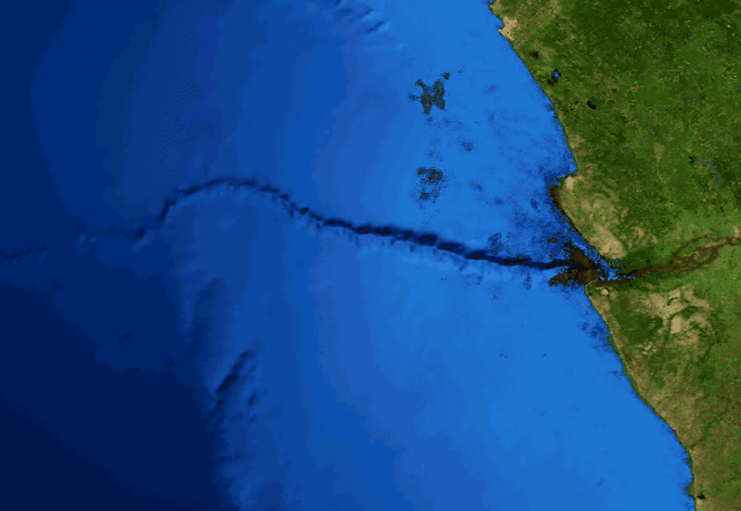
Congo Canyon
Congo Canyon is an immense submarine canyon located at the terminus of the Congo River in Africa, ranking among the largest of its kind globally. Its formation is primarily driven by powerful turbidity currents originating from the Congo River's outflow, which act as underwater avalanches, eroding the canyon and transporting vast amounts of sediment to the Congo Deep-Sea Fan. This process prevents delta formation and contributes to one of the world's largest active submarine fan systems.

Aare Gorge
The Aare Gorge is a dramatic canyon carved through a limestone ridge near Meiringen, Switzerland, by the Aare River. Formed approximately 10,000 years ago by glacial meltwater erosion at the end of the Ice Age, this narrow passage features sheer cliffs and is a significant tourist attraction, partly due to its proximity to the famous Reichenbach Falls.

Agawa Canyon
Agawa Canyon is a shallow canyon in Ontario, Canada, formed approximately 1.2 billion years ago by faulting and later carved by the Agawa River. It is now a popular tourist destination within the Agawa Canyon Wilderness Park, accessible by train or hiking trail, and is renowned for its natural beauty, waterfalls, and seasonal foliage.