
Canyon Sainte-Anne
Gorge·Canada·Precambrian·Sainte-Anne-du-Nord River
Canyon Sainte-Anne is a steep-sided gorge located east of Beaupré, Quebec, Canada, carved by the Sainte-Anne-du-Nord River. The canyon features a prominent 74-meter waterfall and is situated within the ancient geological formations of the Canadian Shield. It has been a site of natural and cultural interest, drawing visitors for its scenic beauty and recreational activities.
Key Facts
- ›Carved by the Sainte-Anne-du-Nord River.
- ›Features a 74-meter (243 ft) waterfall.
- ›Located within the Precambrian Canadian Shield geological formation.
- ›Accessible to the public since 1973.
- ›Receives over 100,000 visitors annually.
- ›Has three suspension footbridges crossing the canyon.
River Erosion, Glacial Erosion
74 M Waterfall, Giant Potholes, Suspension Foot Bridges, Scenic Overlooks
About Canyon Sainte-Anne
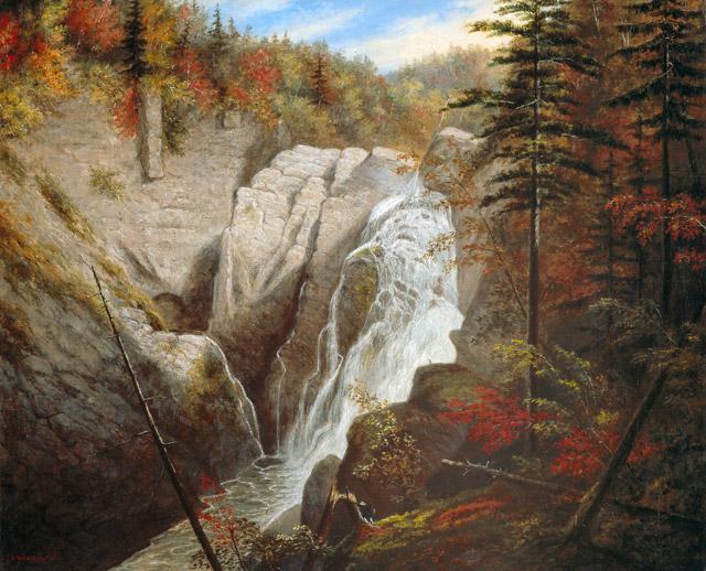
Canyon Sainte-Anne is a prominent natural attraction located 6 kilometers east of Beaupré, Quebec, Canada. This steep-sided gorge was carved by the Sainte-Anne-du-Nord River, which plunges over a spectacular 74-meter (243 ft) waterfall within the canyon. Situated within the ancient geological formations of the Canadian Shield, the canyon showcases a history of geological processes spanning millions of years.
Geology and Formation
The bedrock of Canyon Sainte-Anne is rooted in the Precambrian Age, approximately 1.2 billion years ago, when the Canadian Shield formed. The primary underlying rock is granitic gneiss, a metamorphic rock created under immense pressure and heat deep within the Earth before being uplifted. Later, around 450 million years ago, a layer of sedimentary marine mud was deposited, which consolidated into shale. This shale was subsequently metamorphosed into slate during the Acadian orogeny, about 375 million years ago. Slate, a hard and resistant rock, proved crucial in withstanding the erosive forces of the river. The landscape was further sculpted by two successive ice ages, with the advance and recession of glaciers shaping the region. When the ice melted, the Atlantic Ocean temporarily advanced, forming the Champlain Sea and depositing more recent sediments. The subsequent geological rebound of the Earth's crust, combined with ongoing erosion, established the present-day landscape.
Visitor Experience and Activities
Accessible to the public since July 14, 1973, Canyon Sainte-Anne welcomes over 100,000 visitors annually. The site features three suspension footbridges that span the gorge, including one positioned 60 meters above the river, offering breathtaking views. Numerous scenic overlooks provide families with opportunities to observe giant potholes and other cascades. For those seeking adventure, the canyon offers opportunities for rock-climbing, via ferrata (the first installed in Canada), and rappelling down the canyon walls, all of which are permitted with proper supervision.
Historical and Cultural Context
Historically, the Sainte-Anne-du-Nord River was a vital route for loggers in the early 20th century. The canyon's natural beauty also drew the attention of notable figures; it was familiar to indigenous peoples, painted by Cornelius Krieghoff, and visited by American philosopher and environmentalist Henry David Thoreau. The canyon's dramatic scenery was even utilized for filming exterior scenes of the movie "Battlefield Earth" in 2000. The development into a public attraction began in the late 1960s when Jean-Marie and Laurent McNicoll leased the riverbanks and developed access, paving the way for its opening to visitors.
Canyon Sainte-Anne has received several accolades for its natural appeal and contribution to tourism, including awards for "Natural Outdoor Site" and "Responsible and durable tourism." It is located in a region rich with other attractions, such as Montmorency Falls and the Sainte-Anne-de-Beaupré Shrine.
Source: Wikipedia ↗
Frequently Asked Questions
What is Canyon Sainte-Anne?
Canyon Sainte-Anne is a steep-sided gorge in Quebec, Canada, carved by the Sainte-Anne-du-Nord River. It is known for its dramatic waterfall, scenic overlooks, and recreational opportunities, attracting over 100,000 visitors each year.
What is the geology of Canyon Sainte-Anne?
The canyon is part of the Canadian Shield, with its underlying rock being granitic gneiss formed in the Precambrian Age. Later, shale, metamorphosed into slate, was deposited and hardened, providing resistance to the river's erosive power. Glacial activity from successive ice ages also played a significant role in shaping the current landscape.
What activities can be done at Canyon Sainte-Anne?
Visitors can enjoy scenic overlooks, discover giant potholes and cascades, and cross suspension bridges. More adventurous activities include rock-climbing, via ferrata, and rappelling the canyon walls, which are permitted with supervision.
When is Canyon Sainte-Anne open?
Canyon Sainte-Anne is open seasonally, typically from May to October, to allow visitors to experience its natural beauty and engage in its offered activities.
Where is Canyon Sainte-Anne located?
Canyon Sainte-Anne is situated 6 km east of Beaupré, Quebec, Canada, about 25 to 30 minutes east of Quebec City. It lies on the border between the municipalities of Saint-Ferréol-les-Neiges and Saint-Joachim.
What is the significance of the Sainte-Anne-du-Nord River to the canyon?
The Sainte-Anne-du-Nord River is the primary agent responsible for carving the steep-sided gorge of Canyon Sainte-Anne. It flows through the canyon and culminates in a significant 74-meter waterfall within its depths.
Related Canyons

Black Canyon of the Gunnison
The Black Canyon of the Gunnison is a dramatic gorge in western Colorado, carved by the Gunnison River. Its name derives from the fact that its sheer walls receive very little sunlight, often appearing black. The canyon is renowned for its extreme depth, steepness, and narrowness, combining these features into a formidable and awe-inspiring landscape.
Westwater Canyon
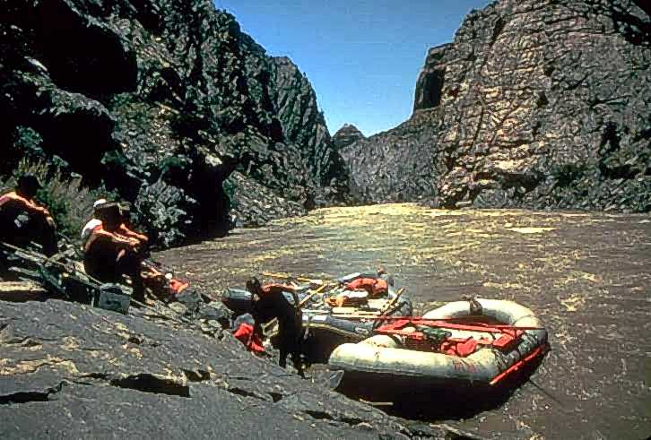
Westwater Canyon is a narrow gorge carved by the Colorado River in eastern Utah, notable for its exposed Precambrian basement rocks within the inner gorge. It features challenging Class III and IV rapids, including the significant "Skull" rapid, making it a draw for whitewater enthusiasts. The canyon is managed by the Bureau of Land Management, which oversees a permitting system for river travelers.

Keystone Canyon
Keystone Canyon is a narrow gorge in Alaska, characterized by its nearly perpendicular slate walls. Carved by the Lowe River, it stretches for approximately 3 miles and serves as a dramatic passage connecting the river's upper and lower valleys. The canyon is notable for its impressive waterfalls, including Horsetail Falls and Bridal Veil Falls, and holds historical significance related to early Alaskan exploration and proposed railroad routes.