
Cotahuasi Canyon
River Canyon·Peru·Cotahuasi River
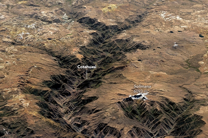
Cotahuasi Canyon, located in southern Peru near Arequipa, is recognized as one of the world's deepest canyons, significantly exceeding the depth of the Grand Canyon. It was carved by the Cotahuasi River between the towering Coropuna and Solimana mountain massifs, showcasing a dramatic landscape with diverse ecosystems and rich pre-Inca heritage.
Key Facts
- ›One of the deepest canyons globally, with a depth of approximately 3,354 meters.
- ›Carved by the Cotahuasi River between the Coropuna (6,425 M) and Solimana (6,093 M) mountain massifs.
- ›Extends from the Solimana mountain spurs to its confluence with the Ocoña River.
- ›The Cotahuasi River originates from Lake Wansuqucha at over 4,750 meters above sea level.
- ›Preserves an integrated environment within the Cotahuasi Subbasin Landscape Park, established in 2005.
- ›Features extensive agricultural terraces dating back to Inca and pre-Inca times.
Kutawasi
River Erosion
Agricultural Terraces, Inca and Pre-Inca Works, Diverse Ecosystems, Endemic Medicinal Plants
Cold Desert Areas, Medicinal Plants
Kutawasi
About Cotahuasi Canyon
Cotahuasi Canyon, originating from the Quechua name Kutawasi, is a profoundly deep canyon situated in the Arequipa region of southern Peru. It stands as one of the world's most significant canyons, with a remarkable depth of approximately 3,354 meters (11,004 ft). This depth is measured from the river level to the summits of the adjacent mountain massifs, Coropuna and Solimana, making it more than twice as deep as the Grand Canyon.
Formation and Geography
The immense chasm was carved by the persistent erosive power of the Cotahuasi River. The river's journey begins at Lake Wansuqucha, situated at an elevation exceeding 4,750 meters (15,580 ft). Along its course, it is joined by several tributaries before eventually merging with the Maran River to form the Ocoña River, which flows onward to the Pacific Ocean. The canyon is dramatically bordered by the imposing peaks of the Coropuna (6,425 m) and Solimana (6,093 m) mountains, creating a striking geological contrast.
Access and Protected Status
Access to Cotahuasi Canyon is primarily via a road that connects to the Panamerican Highway near Arequipa, passing through Chuquibamba and Aplao. The journey is lengthy, typically 10-12 hours by bus, and involves traversing high mountain passes. The Cotahuasi Subbasin has been designated as a landscape park since 2005, covering an area of 4,905.5 km2. This protected status aims to maintain an integrated environment where human activities and nature exist in harmony, preserving a unique cultural microcosm.
Cultural and Agricultural Significance
The difficult topography of the region has fostered the development of remarkable agricultural terraces, remnants of Inca and pre-Inca ingenuity that are still functional today. The area is characterized by its diverse ecological zones, ranging from the river's edge to arid high-altitude deserts, encompassing 12 distinct ecosystems. Organic agriculture is prevalent, with crops like kiwicha, quinoa, and various types of maize grown for local consumption, emphasizing food autonomy through ecological techniques and biodiversity conservation. The region also boasts a rich tapestry of cultural traditions, including weaving, the presence of colonial churches, ancient Inca tracks, and numerous festivals, all maintained by the local Andean communities.
Source: Wikipedia ↗
Frequently Asked Questions
How deep is Cotahuasi Canyon?
Cotahuasi Canyon is approximately 3,354 meters (11,004 ft) deep. This measurement is taken from the river level to the peak of the adjacent mountains, making it more than twice as deep as the Grand Canyon.
What geological processes formed Cotahuasi Canyon?
The canyon was primarily eroded by the Cotahuasi River. This river carved its path between two significant mountain massifs, Coropuna and Solimana, over a considerable geological timescale.
What are the main geographical features of Cotahuasi Canyon?
The canyon is defined by its extreme depth, flanked by the high peaks of the Coropuna and Solimana mountains. The Cotahuasi River flows through its base, originating from a high-altitude lake and passing through various ecological zones.
How can I access Cotahuasi Canyon?
Access to Cotahuasi Canyon is via a road that passes through Chuquibamba and Aplao, beginning from the Panamerican Highway near Arequipa. Daily bus services from Arequipa take 10-12 hours, with the road becoming unpaved after Chuquibamba and crossing a high mountain pass.
Is Cotahuasi Canyon a protected area?
Yes, the Cotahuasi Subbasin is designated as a landscape park, established by a decree in 2005. This reserve covers 4,905.5 km2 and aims to preserve the integrated environment where nature and human activity coexist harmoniously.
What kind of tourism is available in Cotahuasi Canyon?
Tourism in Cotahuasi Canyon focuses on its preserved natural and cultural heritage. Visitors can explore diverse landscapes ranging from the river's bottom to cold desert summits, observe numerous ecosystems, and discover Inca and pre-Inca agricultural terraces, weaving traditions, colonial churches, and ancient Inca trails.
Related Canyons

Colca Canyon
The Colca Canyon is one of the deepest canyons in the world, located in southern Peru near Arequipa. Carved by the Colca River, it features a colorful Andean valley with pre-Inca inhabitants who maintain ancestral traditions and cultivate stepped terraces. The canyon is a significant tourist destination, renowned for its dramatic landscapes, rich indigenous cultures, and the presence of the Andean condor.

Aare Gorge
The Aare Gorge is a dramatic canyon carved through a limestone ridge near Meiringen, Switzerland, by the Aare River. Formed approximately 10,000 years ago by glacial meltwater erosion at the end of the Ice Age, this narrow passage features sheer cliffs and is a significant tourist attraction, partly due to its proximity to the famous Reichenbach Falls.

Agawa Canyon
Agawa Canyon is a shallow canyon in Ontario, Canada, formed approximately 1.2 billion years ago by faulting and later carved by the Agawa River. It is now a popular tourist destination within the Agawa Canyon Wilderness Park, accessible by train or hiking trail, and is renowned for its natural beauty, waterfalls, and seasonal foliage.