
Fraser Canyon
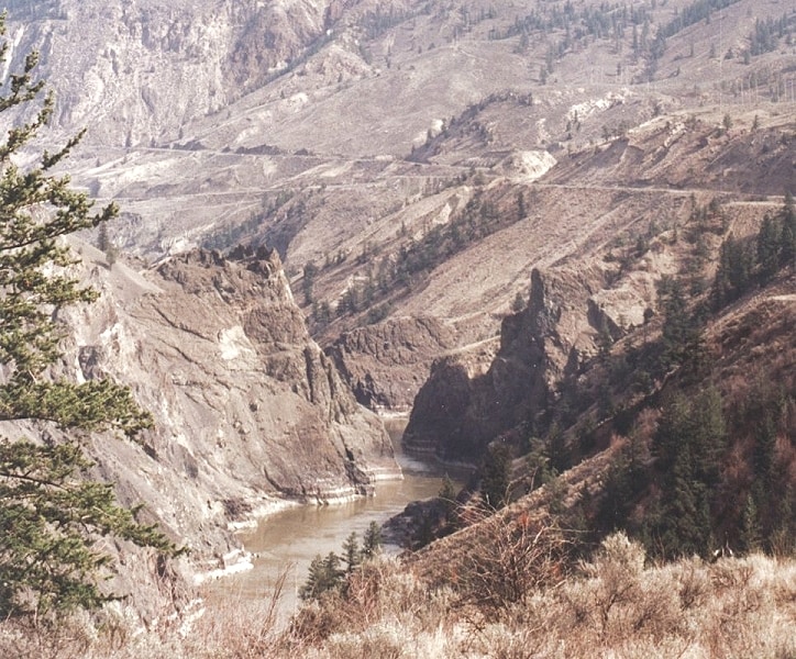
Fraser Canyon is a significant landform carved by the Fraser River as it descends through narrow rock gorges in British Columbia's Coast Mountains. Formed during the Miocene period by river erosion cutting into the uplifting Interior Plateau, it served as a crucial, albeit perilous, transportation corridor during the frontier era and continues to be a vital route for railways and highways. The canyon is characterized by its dramatic cliffs, deep gorges, and historically significant sites like Hells Gate, a major bottleneck for salmon migration and a former gold rush town.
Key Facts
- ›Extends approximately 270 kilometers (170 miles) north of Yale to the confluence of the Chilcotin River.
- ›Formed during the Miocene period by the Fraser River cutting into the uplifting Interior Plateau.
- ›Features volcanic lava flow exposures from the Pliocene period.
- ›Serves as a major transportation corridor for Canadian National and Canadian Pacific Railways, and the Trans-Canada Highway.
- ›Contains notable sub-canyons such as Hells Gate, Big Canyon, and Lillooet Canyon.
- ›Archaeological evidence indicates human presence dating back 8,000 to 10,000 years.
Black Canyon (sections), Big Canyon
River Erosion, Tectonic Activity
Hells Gate, Cisco Bridges, Fraser Fault, Lava Flow Exposures, Fish Ladders, Highway Tunnels, Railway Tunnels, Archaeological Sites
Salmon
Arid Benchland
About Fraser Canyon
Fraser Canyon is a dramatic and historically significant landform in British Columbia, Canada, where the Fraser River carves its way through the rugged Coast Mountains. This natural gorge extends approximately 270 kilometers (170 miles) from Yale northward to the confluence of the Chilcotin River, with its geology shaped by both river erosion and tectonic activity along the Fraser Fault.
Geological Formation and Features
The canyon's formation began during the Miocene period, with the Fraser River cutting deeply into the uplifting Interior Plateau. Evidence of volcanic activity from the Pliocene period is present in the form of lava flows that adorn the canyon walls. Notable geological features include the dramatic narrowing of the river at Hells Gate, a critical point for salmon migration, and the Cisco bridges where two major railways switch sides of the canyon. The canyon system itself encompasses numerous sub-canyons, such as the Big Canyon, Lillooet Canyon, and Fountain Canyon.
Transportation and Human History
Historically, Fraser Canyon presented a formidable obstacle to travel between the Lower Mainland and the Interior Plateau. Despite its challenges, it became a vital transportation corridor. The construction of the Cariboo Wagon Road, followed by the Canadian Pacific and Canadian National Railways, and later the Trans-Canada Highway, involved considerable engineering feats, with railways and highways carved directly into the canyon's rock faces. These routes, while essential, were often precariously situated. The canyon also holds deep historical significance for Indigenous peoples, with archaeological evidence pointing to continuous occupation for at least 8,000 to 10,000 years. The Fraser Canyon Gold Rush of 1858–1860 was a pivotal event, bringing a surge of prospectors and leading to the establishment of numerous settlements, though also to conflict such as the Fraser Canyon War.
Modern Significance
Today, Fraser Canyon remains a crucial artery for commerce and travel, with its railways and highways continuing to serve as lifelines. The area around Hells Gate has been developed into a tourist attraction, featuring an aerial tramway that offers views of the turbulent waters and the surrounding landscape. The canyon's rugged beauty and historical depth continue to draw visitors and researchers alike.
Source: Wikipedia ↗
Frequently Asked Questions
How was Fraser Canyon formed?
Fraser Canyon was primarily formed during the Miocene period by the Fraser River cutting into the uplifting Interior Plateau. This geological process involved the river's erosive power over millions of years, shaping the deep gorges and narrow rock formations.
What are the main transportation routes through Fraser Canyon?
The canyon is a vital transportation corridor, featuring the Canadian National and Canadian Pacific Railways, as well as the Trans-Canada Highway (Highway 1). Other provincial highways, like BC Highway 12 and BC Highway 99, also traverse sections of the canyon.
What is Hells Gate and why is it significant?
Hells Gate is a dramatic section of Fraser Canyon near Boston Bar where the canyon walls rise steeply and the river narrows considerably. It is significant due to the rapids that impede salmon migration; fish ladders were constructed to help bypass a rockslide that occurred in 1913. The area was also a focal point during the Fraser Canyon Gold Rush.
What is the geological history of Fraser Canyon?
The canyon's formation began in the Miocene epoch. Later, during the Pliocene period, volcanic activity in the southern Chilcotin Group resulted in lava flow exposures visible in the canyon's cliffs. The river's path generally follows the line of the Fraser Fault.
What are some notable sub-canyons within the Fraser Canyon system?
Fraser Canyon includes several named sub-canyons. These include the Little Canyon, Big Canyon (also known as Black Canyon during the gold rush), Hells Gate Canyon, Lillooet Canyon, Fountain Canyon, and Glen Fraser Canyon, among others.
What is the human history associated with Fraser Canyon?
Evidence suggests human presence in the area dating back 8,000 to 10,000 years. The canyon was a key site during the Fraser Canyon Gold Rush of 1858-1860, and later became a critical route for the construction of railways and highways, including the Cariboo Wagon Road and the Trans-Canada Highway.
Related Canyons

French Bar Canyon
French Bar Canyon is a significant natural feature located on the Fraser River in British Columbia, Canada. It is situated approximately 60 km upstream from Lillooet, near the communities of Big Bar and Jesmond. The canyon gained attention in June 2019 due to a landslide that occurred within its confines, obstructing the migration route for spawning salmon.

Columbia River Gorge
The Columbia River Gorge is a significant canyon carved by the Columbia River as it flows westward through the Cascade Range, forming the boundary between Washington and Oregon. This 130 km (80 mile) long and up to 1,200 m (4,000 ft) deep water gap is the sole navigable route through the Cascades and the only water connection between the Columbia Plateau and the Pacific Ocean. It is a popular recreational destination and federally protected as the Columbia River Gorge National Scenic Area.

Cromwell Gorge
Cromwell Gorge is a steep gorge carved by the former Clutha River in New Zealand's Central Otago region. It winds between the Dunstan and Cairnmuir Mountains, historically significant for gold mining and fruit orchards. The gorge and parts of old Cromwell were flooded in the early 1990s to create Lake Dunstan behind the Clyde Dam.