
Hells Canyon
River Gorge·North America·Snake River·Basalt
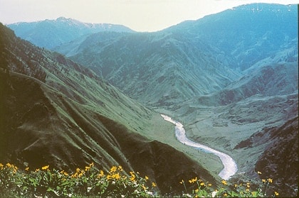
Hells Canyon is North America's deepest river gorge, carved by the Snake River along the borders of Oregon, Idaho, and Washington. Its dramatic landscape features immense depth and a diverse geological history spanning millions of years, from ancient volcanoes to basalt lava flows. The canyon is a significant natural area, offering abundant recreational opportunities and holding historical importance for indigenous tribes and early explorers.
Key Facts
- ›North America's deepest river gorge, reaching 7,993 feet (2,436 M) in depth.
- ›Carved by the Snake River, flowing over a mile below the canyon's west rim.
- ›Geological history dates back 300 million years with volcanic activity and sedimentary rock formation.
- ›Canyon carving by rivers began approximately 6 million years ago.
- ›Part of the Hells Canyon National Recreation Area, encompassing 214,000 acres of wilderness.
- ›Offers a variety of recreational activities including rafting, hiking, fishing, and hunting.
Box Canyon, Snake River Canyon
River Erosion, Volcanic Activity, Tectonic Activity
Seven Devils Mountains, Snake River Rapids, Pictographs and Petroglyphs
Elk, Mountain Goats, Mountain Lions, Mule Deer, Whitetail Deer, Black Bears, Anadromous Fish
Dense Forests, Dry Desert Environment
About Hells Canyon
Hells Canyon is a monumental river gorge situated in the western United States, straddling the borders of eastern Oregon, western Idaho, and a sliver of eastern Washington. Renowned as North America's deepest river gorge, it plunges an astonishing 7,993 feet (2,436 meters) below the peaks of Idaho's Seven Devils Mountains, exceeding the depth of Arizona's Grand Canyon.
The dramatic landscape of Hells Canyon was sculpted over millions of years. Its geological origins trace back 300 million years to volcanic arcs emerging from the Pacific Ocean, followed by the formation of limestone and sedimentary basins. Between 130 and 17 million years ago, these formations became part of the North American continent, leading to extensive basalt lava flows that created a high plateau. Approximately 6 million years ago, rivers began to carve into this plateau, with the Snake River playing a pivotal role in shaping the canyon, especially after the overflow of Lake Idaho around 3 million years ago.
Human history in Hells Canyon is ancient and varied. The Nez Percé tribe were among its earliest known inhabitants, attracted by the mild winters and abundant resources. Pictographs and petroglyphs on the canyon walls serve as testament to these early settlements. European exploration began with the Lewis and Clark Expedition and later expeditions seeking passage. The mid-19th century brought miners, drawn by gold discoveries, and later, hard-rock mining. A short-lived homesteading boom occurred in the 1880s, but the environment proved challenging for agriculture. The canyon also holds the somber history of the Hells Canyon Massacre in 1887. In the mid-20th century, the potential for hydroelectric power led to the construction of the Brownlee, Oxbow, and Hells Canyon Dams on the Snake River, significantly altering the river's flow and impacting anadromous fish migration.
Today, Hells Canyon is a designated National Recreation Area, encompassing a vast expanse of wilderness. It is celebrated for its recreational opportunities, including whitewater sports on the Snake River, fishing, hunting, hiking, and jet boat tours. The canyon's varied ecosystems range from dense forests on its rims to arid desert environments at its base, supporting diverse wildlife. Despite its rugged terrain, access is available via limited roads and viewpoints, making it a significant destination for adventurers and nature enthusiasts.
Source: Wikipedia ↗
Frequently Asked Questions
How deep is Hells Canyon?
Hells Canyon is North America's deepest river gorge, reaching a maximum depth of 7,993 feet (2,436 meters). This depth is greater than that of the Grand Canyon in Arizona.
What geological processes formed Hells Canyon?
The canyon was primarily carved by the Snake River over millions of years. The underlying geology developed from ancient volcanic arcs, subsided volcanoes, and sedimentary rock buildup, followed by extensive basalt lava flows that formed a high plateau before the river began its erosional work.
What kind of rocks are found in Hells Canyon?
The geological history of Hells Canyon involves a variety of rock types. It began with ancient volcanoes, followed by the buildup of limestone on underwater platforms, and later, widespread deposition of basalt lava flows that smoothed the topography into a plateau.
What are the main recreational activities in Hells Canyon?
Hells Canyon is a popular destination for outdoor recreation. Activities include jet boat tours, whitewater sports like rafting and kayaking, fishing, hunting, hiking, and camping, all largely facilitated by the presence of the Snake River.
Is Hells Canyon accessible by road?
Much of Hells Canyon is inaccessible by road, preserving its wilderness character. However, there are limited roads that lead to the Snake River, and viewpoints accessible by road exist on the canyon rims.
What is the history of human habitation in Hells Canyon?
The earliest known residents were the Nez Percé tribe, with other tribes like the Shoshone-Bannock, northern Paiute, and Cayuse also visiting the area. Early explorers and miners also attempted to traverse and exploit the canyon, and there is evidence of a short-lived homesteading period and a tragic massacre of Chinese gold miners.
Related Canyons
Grand Coulee
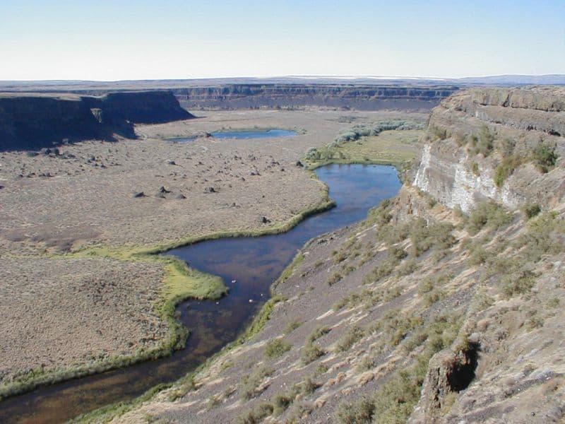
Grand Coulee is an ancient, 60-mile-long river bed in Washington State, U.S., bisected by Dry Falls into the Upper and Lower Grand Coulee. This immense geological feature was primarily carved by catastrophic glacial floods originating from Glacial Lake Missoula during the Pleistocene epoch, a process that stripped away soil and carved deep canyons. Today, the Upper Grand Coulee serves as Banks Lake, a vital part of the Columbia Basin Project for irrigation and recreation.

Moses Coulee
Moses Coulee is a significant canyon located in the Waterville Plateau region of Douglas County, Washington. It is the second-largest and westernmost canyon of the Channeled Scablands, believed to have been carved by immense glacial outburst floods during past ice ages, with discharges exceeding 600,000 m3/s. The coulee's formation is attributed to glacial meltwaters, though the precise origins and age of these floods remain debated among researchers, with theories pointing to floods from glacial Lake Missoula or subglacial floods from the Okanogan Lobe.

Rio Grande Gorge
The Rio Grande Gorge is a deep, eroded chasm in northern New Mexico, carved by the Rio Grande River through the basalt flows of the Taos Plateau. Formed over millions of years by a combination of volcanic activity, tectonic plate shifts, and erosion, it is now a significant geological feature and a protected natural area. The gorge is notable for its diverse ecosystem, historical petroglyphs, and recreational opportunities, including whitewater rafting and hiking.