
Quechee Gorge
River Canyon·North America·Devonian·Ottauquechee River
The Quechee Gorge in Vermont is the state's deepest gorge, carved approximately 13,000 years ago by the Ottauquechee River during the retreat of the Laurentide Ice Sheet. It is a significant geological feature, cutting through Devonian bedrock, and is a popular tourist destination offering scenic views and recreational opportunities along the river.
Key Facts
- ›The Quechee Gorge is 165 feet deep.
- ›It is the deepest gorge in Vermont.
- ›Carved approximately 13,000 years ago by the Ottauquechee River.
- ›Formation occurred as the Laurentide Ice Sheet retreated and glacial Lake Hitchcock drained.
- ›The gorge cuts through bedrock of the Devonian Gile Mountain Formation.
- ›Mesozoic mafic dikes are visible on the west wall.
River Erosion, Glacial Lake Drainage
Mesozoic Mafic Dikes On West Wall
About Quechee Gorge
The Quechee Gorge, located in Quechee, Vermont, stands as the deepest gorge in the state, carved by geological forces over millennia. Its dramatic landscape and accessibility have made it a highly regarded tourist destination.
Geology and Formation
The gorge's formation is attributed to the powerful forces of nature approximately 13,000 years ago, during the retreat of the Laurentide Ice Sheet. The Ottauquechee River played a crucial role in its carving, with rapid downcutting believed to have occurred following the drainage of glacial Lake Hitchcock. The rock strata exposed within the gorge belong to the Devonian Gile Mountain Formation, and the west wall features visible Mesozoic mafic dikes, offering a glimpse into the region's complex geological past.
Significance and Accessibility
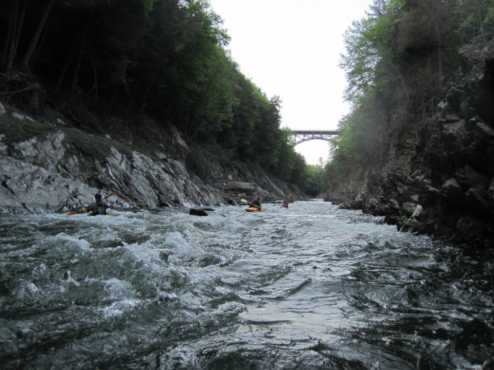
At 165 feet deep, the Quechee Gorge is a striking natural feature that attracts many visitors. It is easily viewed from the U.S. Route 4 bridge, which spans the gorge, and is further complemented by trails along both sides, allowing for exploration and appreciation of its scale. The Ottauquechee River continues to flow through the gorge, providing opportunities for whitewater kayaking and adding to the dynamic character of the area. Its location within Quechee State Park underscores its importance as a protected natural and recreational site.
Source: Wikipedia ↗
Frequently Asked Questions
How was the Quechee Gorge formed?
The Quechee Gorge was carved approximately 13,000 years ago as the Laurentide Ice Sheet retreated. The rapid downcutting of the Ottauquechee River, following the drainage of glacial Lake Hitchcock, is believed to be the primary process responsible for its formation.
What is the geological makeup of the Quechee Gorge?
The gorge cuts through bedrock belonging to the Devonian Gile Mountain Formation. Additionally, Mesozoic mafic dikes can be observed on the west wall of the gorge.
What activities can be done at Quechee Gorge?
The Quechee Gorge is a popular tourist attraction, offering scenic views from the U.S. Route 4 bridge and from trails on both sides. The Ottauquechee River flowing through the gorge is also a popular whitewater kayak run.
Where is the Quechee Gorge located?
The Quechee Gorge is situated in Quechee, Vermont, and can be accessed along U.S. Route 4. It is a prominent feature within Quechee State Park.
Related Canyons

Genesee River Gorge
Letchworth State Park is a vast New York State Park carved by the Genesee River, renowned for its deep gorge and three prominent waterfalls. Often called the "Grand Canyon of the East," the park's geological features were shaped by glacial activity and river erosion over Devonian bedrock, and it holds significant cultural and historical importance, including the legacy of its founder, William Pryor Letchworth, and the ancestral lands of the Seneca people.

Windjana Gorge
Windjana Gorge, also known as Bandiln͟gan, is a significant gorge located in the Kimberley region of Western Australia, within Windjana Gorge National Park. It was formed by the Lennard River eroding a 3.5-kilometer section of the ancient Devonian limestone Napier Range, which is over 300 million years old. The gorge is renowned for its easily accessible hiking trails during the dry season, permanent waterholes, and the visible marine fossils embedded in its walls, making it a popular tourist attraction.

Wintergreen Gorge
Wintergreen Gorge is a six-mile-long canyon in Erie County, Pennsylvania, carved by Fourmile Creek. Its formation began approximately 11,000 years ago through the erosion of glacial debris and Devonian shale. The gorge is known for its diverse plant and animal life, as well as its namesake wintergreen plants, and is partially located on the campus of Penn State Behrend.