
Samaria Gorge
The Samariá Gorge is a National Park in southwest Crete, Greece, renowned as a major tourist attraction and a World's Biosphere Reserve. Carved by a small river between the White Mountains and Mt. Volakias, it stretches 16 km from an altitude of 1,250 m to the Libyan Sea. The gorge is significant as a refuge for the rare kri-kri (Cretan goat) and other endemic species.
Key Facts
- ›The gorge is 16 km long, starting at 1,250 M altitude and ending at the Libyan Sea.
- ›The walk through the national park is 13 km, with an additional 2 km to Agia Roumeli, totaling a 15 km hike.
- ›The narrowest section, known as the Gates, is only four meters wide with walls soaring up to 300 meters.
- ›It became a National Park in 1962 to protect the endemic kri-kri (Cretan goat).
- ›The village of Samariá, located within the gorge, was abandoned in 1962 to establish the park.
- ›Visits are permitted from May 1 to October 31, with daily park hours from 07:00 to 15:00.
Φαράγγι Σαμαριάς, Φάραγγας
River Erosion
the Gates, Omalos Plateau
Kri-Kri, Endemic Species, Birds
Flowers
About Samaria Gorge
Samariá Gorge
The Samariá Gorge, also known by its Greek names Φαράγγι Σαμαριάς or Φάραγγας, is a prominent natural landmark located in southwest Crete, Greece, within the regional unit of Chania. Established as a National Park of Greece in 1962, it is recognized internationally as a World's Biosphere Reserve and is a major tourist attraction for the island.
Formation and Dimensions
The gorge was formed by the erosive power of a small river flowing between the White Mountains (Lefká Óri) and Mt. Volakias. While the total length from the Omalos plateau to the Libyan Sea is often cited as 18 km, the gorge itself is approximately 16 km long. It begins at an altitude of 1,250 meters at its northern entrance and concludes at the coastal village of Agia Roumeli on the Libyan Sea. The hiking trail through the National Park covers 13 km, with an additional 2 km required to reach Agia Roumeli from the park's exit, making the total hike approximately 15 km. The most dramatic and famous section is known as the Gates, where the canyon walls converge to a mere four-meter width, soaring upwards to a height of nearly 300 meters.
Ecological Significance and Access
Samariá Gorge was designated a national park primarily to serve as a refuge for the endangered kri-kri, or Cretan goat, which is largely confined to this protected area and a small island offshore. The gorge and its surroundings are also home to a variety of other endemic species, numerous types of flowers, and diverse birdlife. The village of Samariá, located within the gorge, was abandoned by its final inhabitants in 1962 to facilitate the park's creation. The name 'Samariá' itself originates from the ancient church of Óssia María within the village.
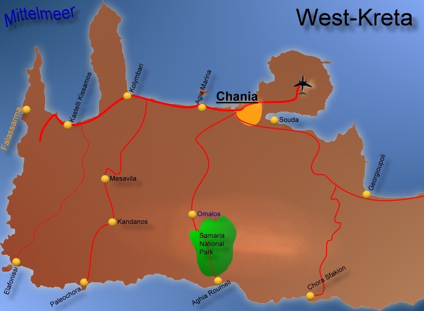
Visitors can experience the gorge by hiking the route from the Omalos plateau to Agia Roumeli. This trek typically takes between five to seven hours and can be physically demanding, particularly during the hotter summer months. Upon reaching Agia Roumeli, hikers usually board ferries to the nearby villages of Sougia or Hora Sfakion, from where they can arrange onward travel, often by coach, back to Chania. Organized tours are readily available, providing transportation from hotels to the gorge entrance and coordinating ferry and bus connections for the return journey. Access to the National Park is permitted from May 1st to October 31st, with daily visiting hours from 7:00 AM to 3:00 PM. After 3:00 PM, visitors are restricted to walking a short distance from either Xyloskalo or Agia Roumeli. Camping, overnight stays, fires, and swimming in the gorge's streams are strictly forbidden within the park.
Source: Wikipedia ↗
Frequently Asked Questions
How long is the Samariá Gorge?
While some sources state 18 km, the actual length of the Samariá Gorge is 16 km. This distance is measured from its northern entrance at an altitude of 1,250 meters to its exit on the shores of the Libyan Sea.
What is the most famous part of the Samariá Gorge?
The most famous section is called the Gates, where the gorge walls narrow to just four meters in width and rise dramatically to nearly 300 meters in height. This striking feature is often incorrectly referred to as the 'Iron Gates'.
What kind of wildlife can be found in Samariá Gorge?
Samariá Gorge is a vital refuge for the rare kri-kri, also known as the Cretan goat. The park is also home to several other endemic species, along with numerous varieties of flowers and birds.
When can visitors enter the Samariá Gorge?
Visits to the Samariá National Park are allowed annually from May 1st to October 31st. The park is open daily from 7:00 AM to 3:00 PM, with restricted access for walking after 3:00 PM.
What activities are prohibited in Samariá Gorge?
Within the Samariá National Park, camping, staying overnight, lighting fires, and swimming in the gorge's streams are strictly prohibited to preserve the environment and its wildlife.
How do people typically access and exit Samariá Gorge?
Visitors usually hike down the gorge from the Omalos plateau to the village of Agia Roumeli on the Libyan Sea. From Agia Roumeli, they take a ferry to nearby villages like Sougia or Hora Sfakion, where transportation back to Chania is available.
Related Canyons

Richtis Gorge
Richtis Gorge is a state-protected park in eastern Crete, Greece, known for its diverse hiking experience. The gorge, formed by natural erosion, stretches approximately 4 km from the village of Exo Mouliana to Richtis beach, featuring rich vegetation, historical stone bridges, water mills, and culminating in the Richtis Waterfall.

Vikos Gorge
The Vikos Gorge is a dramatic gorge located in the Pindus Mountains of northwestern Greece, renowned for being the deepest canyon relative to its width in the world. Carved over millions of years by the Vikos Stream and the Voidomatis River, it showcases diverse geological strata and ecosystems. Historically, the area was utilized for pastoralism and is significant for its unique flora, with local healers known as "Vikos doctors" using medicinal herbs found within the gorge.

Agia Eirini Gorge
Agia Eirini Gorge is a scenic canyon located in southwestern Crete, Greece, renowned for its natural beauty and historical significance. Stretching 7.5 kilometers from the village of Agia Eirini to the coastal village of Sougia, it features steep mountain cliffs and forested areas. The gorge played a role in history, notably as an escape route for civilians during Ottoman rule.