
Cotopaxi
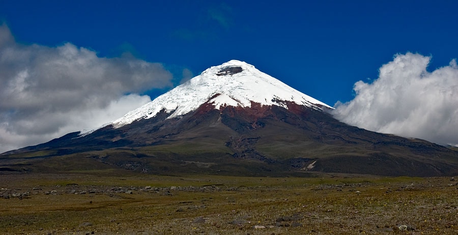
Cotopaxi is an active stratovolcano in Ecuador's Andes Mountains, renowned for its near-perfect conical shape and its significant equatorial glacier. It is one of the world's highest active volcanoes and has a history of frequent and powerful eruptions, which have shaped the surrounding landscape with lahars and pose a risk to nearby populations.
Key Facts
- ›Cotopaxi is an active stratovolcano located in the Andes Mountains of Ecuador.
- ›It is one of the highest active volcanoes globally, reaching an elevation of 5,897 meters (19,347 ft).
- ›The volcano has erupted 87 times in recorded history, with the first eruption documented in 1534.
- ›Its summit features one of the world's few equatorial glaciers.
- ›Major historical eruptions in 1742, 1744, 1768, and 1877 caused significant destruction, including leveling the city of Latacunga.
- ›Cotopaxi remains a popular destination for mountaineers and has a history of scientific observation and tracking station use.
Known For
- Its near-symmetrical cone shape
- Being one of the highest active volcanoes in the world
- Its equatorial glacier
- History of powerful eruptions and lahars
Near-Symmetrical Cone, Summit Crater, Equatorial Glacier, Lahars Formed By Past Eruptions
Cotopaxi National Park
About Cotopaxi
What is Cotopaxi?
Cotopaxi is a prominent and active stratovolcano situated in the Andes Mountains of Ecuador, within the boundaries of Cotopaxi National Park. Renowned for its near-perfect conical shape, it stands as one of the highest active volcanoes globally, with its summit reaching an elevation of 5,897 meters (19,347 ft). On clear days, its majestic presence is visible from the cities of Latacunga and Quito.
Geological Significance and Activity
Cotopaxi is part of the Pacific Ring of Fire and is known for its frequent and powerful eruptions. Throughout recorded history, it has erupted 87 times, with the earliest documented event dating back to 1534. Its volcanic activity has significantly shaped the surrounding landscape, creating numerous valleys through lahars, or mudflows, that result from eruptions melting its ice cap. Recent seismic activity and sulfur dioxide emissions indicate ongoing unrest, with an eruption beginning in October 2022.
The Equatorial Glacier and Hazards
A unique characteristic of Cotopaxi is its equatorial glacier, which begins at an altitude of approximately 5,000 meters (16,400 ft). The flash-melting of this glacier during major eruptions poses a substantial threat, generating devastating lahars that can travel over 100 km. Historical eruptions, such as those in 1742, 1768, and 1877, have repeatedly destroyed the city of Latacunga due to these mudflows.
Mountaineering and Cultural Importance
Cotopaxi is a significant destination for mountaineers, with guided climbs being a popular draw. The José F. Ribas Refuge, located at 4,864 meters (15,960 ft), serves as a base for summit attempts. The volcano also holds deep cultural significance for local Andean people, historically revered as a sacred mountain and a deity associated with rain and fertility. Its dramatic landscapes have inspired artists, writers, and filmmakers for centuries.
Source: Wikipedia ↗
Frequently Asked Questions
What is Cotopaxi and where is it located?
Cotopaxi is an active stratovolcano situated in the Andes Mountains of Ecuador, within Cotopaxi National Park. It is located approximately 50 km south of Quito.
How high is Cotopaxi?
Cotopaxi reaches a summit elevation of 5,897 meters (19,347 ft), making it the second-highest summit in Ecuador and one of the highest active volcanoes in the world.
What is significant about Cotopaxi's glacier?
Cotopaxi is notable for having one of the world's few equatorial glaciers. This glacier begins at an altitude of approximately 5,000 meters (16,400 ft).
How many times has Cotopaxi erupted?
Cotopaxi has erupted 87 times throughout recorded history, with its first documented eruption occurring in 1534. It experienced a recent eruption starting on October 21, 2022.
What are the dangers associated with Cotopaxi's eruptions?
Eruptions from Cotopaxi, particularly major ones, pose a significant risk due to the potential for flash-melting of its summit glacier. This can lead to devastating lahars (mudflows) that travel long distances down river valleys, threatening settlements like Latacunga and potentially areas near Quito.
Can people climb Cotopaxi?
Climbing Cotopaxi to the summit is a popular activity, with guided climbs offered when conditions are safe. The conventional route is rated as moderately difficult, requiring the use of crampons and ice axes.
Related Glaciers

Antisana
Antisana is a stratovolcano located in the northern Andes of Ecuador, standing as the fourth highest volcano in the country. It is situated approximately 50 kilometers southeast of Quito and presents a formidable challenge for technical climbers.

El Altar
El Altar, also known as Capac Urcu, is an extinct stratovolcano located in Sangay National Park, Ecuador. Its striking horseshoe-shaped ridge of nine peaks, surrounding a central crater lake, makes it a geologically significant and visually dramatic mountain. It is renowned as one of Ecuador's most technically challenging climbs, while also offering accessible hiking routes to its crater lake.

Nevado del Ruiz
Nevado del Ruiz is a stratovolcano in Colombia that is the highest point in both the Caldas and Tolima departments. It is part of the Andes mountain range and is known for its glaciers and its history of devastating lahars, particularly the 1985 eruption that destroyed the town of Armero and caused an estimated 25,000 deaths, making it the deadliest lahar in recorded history.