
Clearwater East
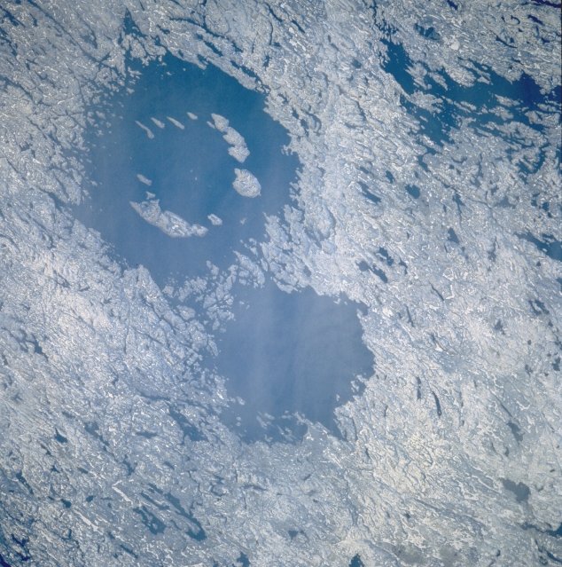
Clearwater East is one of two impact craters, forming the Clearwater Lakes in Quebec, Canada. This complex crater, with a diameter of 26 km, is estimated to be around 460-470 million years old, dating back to the Middle Ordovician period. Its central peak is submerged beneath lake water and sediments, but its presence has been confirmed through geological surveys and core drilling.
Key Facts
- ›Clearwater East is an impact structure with a diameter of 26 km.
- ›It is approximately 460–470 million years old.
- ›The impact event occurred during the Middle Ordovician geological period.
- ›It is a complex crater with a distinct central peak, though submerged.
- ›The crater is located within the Clearwater Lakes, Quebec, Canada.
- ›Albert Peter Low noted the clarity of the lakes in 1896.
About Clearwater East
Clearwater East is one of two impact craters that form the Clearwater Lakes, a significant geological feature located on the Canadian Shield in Quebec, Canada, near Hudson Bay.
Impact Structure
This impact structure is a complex crater with an estimated diameter of 26 kilometers (16 miles). Its central peak, a common feature in complex craters, is submerged beneath the lake's waters and sediments. Despite this cover, bathymetric surveys and core drilling have confirmed its presence. The crater is significantly eroded, obscuring its original surface features.
Age and Formation
Repeated dating of impact melt rocks from Clearwater East suggests an age of approximately 460–470 million years. This places its formation during the Middle Ordovician period. While previously believed to be the same age as the nearby Clearwater West crater, recent evidence indicates different formation times and potentially different impactors, as suggested by distinct geophysical and geochemical signatures.
Discovery and Naming
Explorer and geologist Albert Peter Low, associated with the Geological Survey of Canada, provided an early account of the Clearwater Lakes in 1896, noting the extraordinary clarity of their waters. The lakes' Cree name, Wiyâšâkamî, translates to "clear water," which was later calqued into French as Lac à l'Eau Claire and then officially named Lac Wiyâšâkimî. The English name, Clearwater Lakes, is a direct translation.
Significance
Clearwater East, along with Clearwater West, represents a valuable site for studying impact cratering processes. The presence of submerged central peaks and the distinct geological and geochemical signatures offer insights into the mechanics of large impacts and the nature of the impacting bodies. The area surrounding the lakes is now part of Tursujuq National Park, Quebec's largest national park.
Source: Wikipedia ↗
Frequently Asked Questions
What is Clearwater East?
Clearwater East is an eroded impact crater, part of the Clearwater Lakes structure in Quebec, Canada. It is a geological feature formed by the impact of a celestial body with Earth.
How old is Clearwater East?
Recent dating of impact melt rocks suggests Clearwater East is approximately 460–470 million years old. This places its formation in the Middle Ordovician period.
What is the size of Clearwater East?
The estimated diameter of the Clearwater East impact crater is 26 kilometers (16 miles). It is one of two craters that form the Clearwater Lakes.
What is the morphology of Clearwater East?
Clearwater East is classified as a complex crater. It features a distinct central peak, which is a common characteristic of complex impact structures, although it is submerged by lake water and sediments.
Where are the Clearwater Lakes located?
The Clearwater Lakes, which include the Clearwater East impact structure, are located on the Canadian Shield in Quebec, Canada, near Hudson Bay. They are part of Tursujuq National Park.
Related Impact Craters

Araguainha
The Araguainha crater, located on the border of Mato Grosso and Goiás states in Brazil, is the largest known impact crater in South America, measuring 40 kilometers in diameter. Its age, estimated at 254.7 million years ago, closely overlaps with the Permian-Triassic extinction event, suggesting a potential, though indirect, role in this catastrophic global event.
Kentland
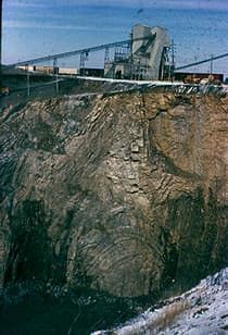
The Kentland structure, located in Newton County, Indiana, is a deeply eroded impact crater first identified by farmers in the late 19th century. Its geological significance lies in the extreme deformation of bedrock, including uplifted ancient rock layers and the presence of shatter cones, which confirmed its extraterrestrial impact origin by the late 1960s. The structure is currently an active quarry.

Decorah
The Decorah crater, located near Decorah, Iowa, is a potential impact structure estimated to be 5.6 km in diameter. It is believed to have formed approximately 470 million years ago during the Middle Ordovician period when a meteor around 200 meters wide struck the Earth, pushing down the underlying bedrock. Despite its significant size, no surface evidence of the impact remains due to burial by the Winneshiek Shale.