
New Quebec/Pingualuit
Canada·Pleistocene·Cenozoic·Chondritic meteorite
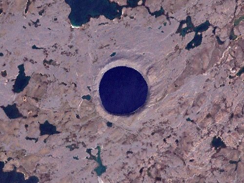
The Pingualuit Crater, also known as the New Quebec Crater, is a remarkably well-preserved impact structure on Ungava Peninsula, Quebec, Canada. Formed by a meteorite impact approximately 1.4 million years ago, it now contains the deep and exceptionally clear Pingualuk Lake, one of the purest freshwater bodies in the world.
Key Facts
- ›Diameter: 3.44 km
- ›Age: Approximately 1.4 million years old (Pleistocene)
- ›Depth: 400 m (crater), 267 m (lake)
- ›Location: Ungava Peninsula, Quebec, Canada
- ›Discovery: Photographed in 1943, scientifically studied from 1950
- ›Morphology: Circular impact crater filled by a lake
Shocked Quartz
About New Quebec/Pingualuit
Pingualuit Crater
The Pingualuit Crater, formerly known as the Chubb Crater and later the New Quebec Crater, is a prominent impact structure located on the Ungava Peninsula in the Nord-du-Québec region of Quebec, Canada. This relatively young crater, with a diameter of 3.44 kilometers, is estimated to be 1.4 million years old, dating back to the Pleistocene epoch. Its near-perfect circular form and the exceptionally deep, clear lake it contains make it a site of significant scientific and natural interest.
Geography and Hydrology
The crater rises 160 meters above the surrounding tundra and reaches a depth of 400 meters. It is filled by Pingualuk Lake, which is 267 meters deep and renowned for holding some of the purest freshwater on Earth, with a salinity of less than 3 parts per million. The lake's clarity is remarkable, with a Secchi disk visible at depths exceeding 35 meters. Lacking inlets or apparent outlets, Pingualuk Lake's water supply comes solely from precipitation, with loss occurring only through evaporation.
Formation and Discovery
The impact event that created Pingualuit occurred approximately 1.4 million years ago. Analysis of impact melt rocks has provided insights into the composition of the impacting bolide, suggesting it was chondritic in nature due to enrichments in iron, nickel, cobalt, and chromium. While the crater was known to local Inuit, its recognition by the outside world began in 1943 when a U.S. Army Air Force plane photographed the feature. Geologist V. Ben Meen, alerted by diamond prospector Frederick W. Chubb, led the first scientific expedition in 1950, initially naming it 'Chubb Crater'. Subsequent expeditions and research, including work by Ursula Marvin and David Kring, have confirmed its impact origin through evidence of shock metamorphism.
Naming and Conservation
The crater's name has evolved over time, reflecting its geographical location and scientific study. It was officially changed to "Cratère du Nouveau-Québec" in 1954 and finally to "Pingualuit" in 1999, a term from the Inuit language meaning "pimple." Today, the crater and its pristine lake are protected within Pingualuit National Park, established in 2004, preserving this unique geological legacy and its remarkable aquatic ecosystem.
Source: Wikipedia ↗
Frequently Asked Questions
What is the Pingualuit Crater?
The Pingualuit Crater is a relatively young impact crater located on the Ungava Peninsula in Quebec, Canada. It is known for its near-perfect circular shape and the exceptionally clear, deep lake it contains.
How old is the Pingualuit Crater?
The crater is estimated to be 1.4 million years old, based on radiometric dating of impact melt rocks. This age places its formation within the Pleistocene epoch.
What caused the Pingualuit Crater?
The crater was formed by the impact of a meteorite. Analysis of impact melt samples suggests the meteorite was chondritic in nature, indicated by enrichments in iron, nickel, cobalt, and chromium.
Who discovered the Pingualuit Crater?
While known to local Inuit, the crater was first photographed by a U.S. Army Air Force plane in 1943. Geologist V. Ben Meen, prompted by diamond prospector Frederick W. Chubb, conducted the first scientific expedition in 1950 and proposed the name 'Chubb Crater'.
What is significant about Pingualuk Lake?
Pingualuk Lake, which fills the Pingualuit Crater, is one of the deepest lakes in North America and holds some of the purest freshwater globally, with exceptionally low salinity and high transparency.
What is the current status of the Pingualuit Crater area?
The Pingualuit Crater and its surrounding area are now protected as part of Pingualuit National Park, established on January 1, 2004. Expeditions continue to study the lake's sediment cores for paleoclimatic data.
Related Impact Craters
Kalkkop
Kalkkop is a confirmed impact crater located in the Eastern Cape Province of South Africa, approximately 50 kilometers southeast of Aberdeen. The impact event occurred about 250,000 years ago, leaving a significant crater that has since been filled with a deep limestone deposit.

Meteor/Barringer
Meteor Crater, also known as Barringer Crater, is one of the best-preserved meteorite impact craters on Earth, located in northern Arizona. Excavated approximately 50,000 years ago by a nickel-iron meteorite, its well-preserved state is attributed to its relatively young age and the arid climate. The crater has been a site of significant scientific investigation and remains privately owned by the Barringer family.

Wolfe Creek
Wolfe Creek Crater, also known as Kandimalal by the local Djaru people, is a remarkably well-preserved meteorite impact crater located in Western Australia. Its pristine condition makes it a significant geological site, comparable to the Barringer Crater in Arizona, and it holds deep cultural importance for Indigenous Australians.