
Kingsley Lake
Kingsley Lake is a nearly circular freshwater sinkhole lake located in Clay County, Florida, distinguished by its near-perfect round shape and its position atop Florida's ancient Trail Ridge. Formed by the dissolution of underlying limestone, it is an oligotrophic body of water with exceptional clarity and minimal nutrient levels, making it a valuable natural resource and a site of ecological and geological interest.
Key Facts
- ›Covers approximately 2,000 acres (810 ha) and is known for its near-perfect circular shape, earning it the nickname "Silver Dollar Lake".
- ›Sits atop Florida's ancient Trail Ridge at approximately 174 ft (53 M) above sea level, one of the state's highest natural elevations.
- ›Formed by the dissolution of underlying limestone bedrock, a characteristic of Florida's karst topography.
- ›Classified as an oligotrophic lake with very low nutrient concentrations and high water clarity.
- ›Has experienced unusual long-term water-level stability, with minor fluctuations recorded between 1945 and 1995.
- ›Public access is limited, with about half the shoreline within Camp Blanding and the remainder privately owned.
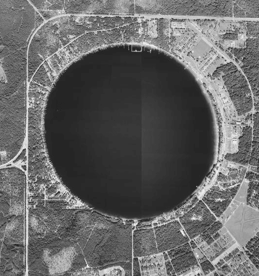
Silver Dollar Lake
Near-Perfect Circular Shape, High Elevation For Florida, Oligotrophic Water Quality
Freshwater, Low Nutrient, Acidic
Largemouth Bass, Bluegill, Crappie, Catfish, Alligators, Turtles, Ospreys, Herons, Egrets, Kingfishers, Gopher Tortoise, Indigo Snake, Red-Cockaded Woodpecker, Florida Black Bears, Black Creek Crayfish
About Kingsley Lake
Kingsley Lake is a unique natural feature located in Clay County, Florida, renowned for its striking near-perfect circular shape, often earning it the nickname "Silver Dollar Lake." This nearly circular freshwater sinkhole lake covers approximately 2,000 acres and is situated at a notable elevation of about 174 feet above sea level, placing it among Florida's highest natural landforms atop the ancient Trail Ridge.
Geological Formation and Hydrology
The lake's formation is a classic example of karst topography, resulting from the dissolution of underlying limestone bedrock by acidic rainwater and groundwater. This process created a deep sinkhole that now holds the lake. Kingsley Lake is classified as an oligotrophic lake, characterized by its exceptionally clear water, very low nutrient levels, and minimal algal growth. Hydrological studies indicate it sits on a perched aquifer system, primarily fed by rainfall and seepage through its sandy bottom, with limited outflow through seepage and seasonal discharge into the North Fork Black Creek. Seismic surveys confirm it occupies a solution-collapse sinkhole, with its sandy bottom largely sealing it from deeper aquifers.
Ecology and Wildlife
The ecology of Kingsley Lake is shaped by its oligotrophic nature. Aquatic vegetation is sparse, particularly in the deeper central basin due to limited light and low nutrients. The lake supports a healthy fish population, including largemouth bass prized for trophy catches, bluegill, crappie, and catfish. The surrounding ecosystem is also home to a variety of wildlife such as alligators, turtles, various water birds like ospreys and herons, and terrestrial animals including gopher tortoises and Florida black bears. The watershed is also recognized as critical habitat for the federally protected Black Creek crayfish.
Human History and Recreation
The area around Kingsley Lake has a long history of human activity, dating back to the Timucuan Native Americans. The lake was likely named after Zephaniah Kingsley, a prominent planter in early 19th-century Florida. From the mid-20th century until 2002, Strickland's Landing served as a popular lakeside resort. Today, public access to Kingsley Lake is significantly limited, with much of the shoreline controlled by Camp Blanding, a Florida National Guard installation, and the remainder privately owned. This restricted access has helped preserve the lake's natural state, protecting it from significant shoreline development and nutrient impairment.
Source: Wikipedia ↗
Frequently Asked Questions
How was Kingsley Lake formed?
Kingsley Lake was formed by geological processes characteristic of Florida's karst topography. The underlying limestone bedrock dissolved when exposed to slightly acidic rainwater and groundwater, creating caverns that eventually collapsed to form the sinkhole.
What is the significance of Kingsley Lake's shape?
Kingsley Lake is nearly perfectly circular, a distinctive feature that has led to its nickname "Silver Dollar Lake." This shape is a notable characteristic among Florida's lakes and is a direct result of its sinkhole formation.
What type of water quality does Kingsley Lake have?
Kingsley Lake is classified as an oligotrophic lake, meaning it has very low nutrient concentrations, high water clarity, and minimal algal growth. Its pH is recorded as acidic, around 5.9, with good dissolved oxygen levels.
What kind of wildlife can be found at Kingsley Lake?
The lake supports a variety of fish, including trophy-sized largemouth bass, bluegill, crappie, and catfish. Alligators, turtles, ospreys, herons, egrets, and kingfishers are also common, and the watershed is critical habitat for the Black Creek crayfish.
Is Kingsley Lake easily accessible to the public?
Public access to Kingsley Lake is very limited. Approximately half of its shoreline is part of the Camp Blanding Florida National Guard installation, and the other half is privately owned by residential properties. There are no public boat ramps or beaches.
What historical uses has Kingsley Lake had?
Historically, the area was inhabited by Native Americans. Later, Zephaniah Kingsley, a 19th-century planter, is believed to have given the lake its name. From 1946 to 2002, Strickland's Landing operated as a popular lakeside resort.
Related Sinkholes

Trout Pond
Trout Pond, formerly known as Old Pond, is West Virginia's only natural lake, formed by a sinkhole that filled with water from mountain streams. It is a karst feature located within the Trout Pond Recreation Area in the George Washington National Forest. While historically a stable body of water, recent underground structural changes in the underlying limestone have caused it to periodically drain, highlighting the dynamic nature of sinkhole formations.

Makauwahi Cave
Makauwahi Cave is the largest limestone cave in Hawaii, located on the south coast of Kauaʻi in the Māhāʻulepū Valley. It is geologically unique as a sinkhole paleolake within eolianite limestone, preserving nearly 10,000 years of sedimentary record. Its significance lies in its rich paleoecological and archaeological findings, offering insights into pre-human conditions and the ecological impact of human colonization.
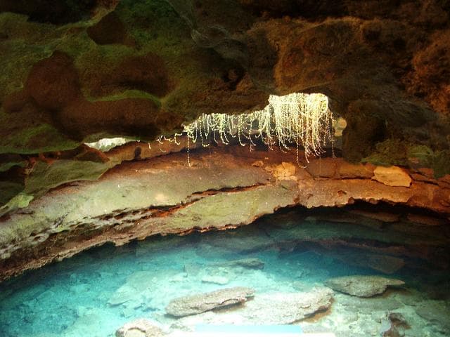
Devil's Den Cave
Devil's Den Cave is a unique solution sinkhole located near Williston, Florida, notable for its ancient paleontological discoveries and its transformation into a recreational SCUBA diving site. The cave features a karst window opening to a geothermally warmed underground river, which, during colder months, produces a visible steam plume reminiscent of a "chimney from Hell" to early settlers. Extensive fossil finds, including those of extinct Pleistocene animals alongside human remains and artifacts, have been documented within its underwater passages, offering a glimpse into prehistoric life.